Michimaloya geodata
Michimaloya (Hidalgo) is a populated place; located in Mexico in America/Mexico_City (GMT-6) time zone. With population of 1,242 people, there are 6984 cities with bigger population in this country. Compared to other cities in Mexico, 58.9% of cities are located further ↓South; 55.6% of cities are located further →East and 77.9% of cities have lower elevation than Michimaloya. Note1


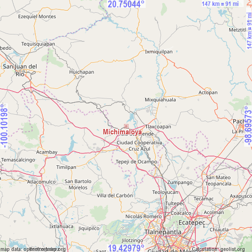
Michimaloya GPS coordinates[2]
20° 5' 29.436" North, 99° 23' 55.86" West
| Map corner | latitude | longitude |
|---|---|---|
| Upper-left | 20.75044°, | -100.10198° |
| Center: | 20.09151°, | -99.39885° |
| Lower-right: | 19.42979°, | -98.69573° |
| Map W x H: | 146.8×146.8 km | = 91.2×91.2mi |
| max Lat: | 32.7° ⇑41.1% North |
| Michimaloya: | 20.09151° |
| min Lat: | ⇓58.9% South 14.53588° |
| min Long | Michimaloya | max Long |
| -117.105° | -99.39885° | -86.73105° |
| W 44.4%⇐ | ⇒55.6% E |
Elevation
Elevation of Michimaloya is 2087 m = 6847 ft, and this is 833.3 m = 2734 ft above average elevation for this country.
| Max E: |
3497 m = 11473 ft | 22.1% |
| Michimaloya | 2087 m 6847 ft | |
| Avg. | 1253.7 m = 4113 ft | |
Min E: |
-1 m = -3 ft | 77.9% |
See also: Mexico elevation on elevation.city.
Geographical zone
Michimaloya is located in North Torrid zone (between Equator and Tropic of Cancer). Distance of this Northern Tropic circle is 372 km =231.2 mi to North.| Distance of | km | miles | from Michimaloya |
|---|---|---|---|
| North Pole | 7773.1 | 4830 | to North |
| Arctic Circle | 5167.2 | 3210.7 | to North |
| Tropic Cancer | 372 | 231.2 | to North |
| Equator | 2234 | 1388.1 | to South |


Nearby cities:
15 places around Michimaloya: (largest is in red/bold)
• Colonia Benito Juárez
6.4 km =4 mi,  74°
74°
• El Crestón
4.7 km =2.9 mi,  134°
134°
• El Llano
8.8 km =5.5 mi,  109°
109°
• General Pedro María Anaya
8.9 km =5.5 mi,  36°
36°
• La Cuarta Manzana
10.4 km =6.5 mi,  5°
5°
• La Loma
8.9 km =5.5 mi, 13°
• Nantzha
5.3 km =3.3 mi,  143°
143°
• Residencial Arboledas
10.6 km =6.6 mi, 106°
• San Andrés
4.6 km =2.9 mi,  154°
154°
• San Marcos
9.5 km =5.9 mi, 135°
• San Pedro Nextlalpan
6.8 km =4.2 mi, 9°
• Santa Ana Ahuehuepan
6.6 km =4.1 mi,  58°
58°
• Santa Maria Macua
9.4 km =5.8 mi,  301°
301°
• Tula de Allende
7.2 km =4.5 mi, 127°
• Xiteje de Zapata
1.2 km =0.7 mi, 58°
Sources, notices
• [Note1] Compared only with cities in Mexico existing in our database
• [Src1] Map data: © OpenStreetMap contributors (CC-BY-SA)
• [Src2] Other city data from geonames.org with taken over terms of usage.
• [Src3] Geographical zone / Annual Mean Temperature by Robert A. Rohde @ Wikipedia
