El Crestón geodata
El Crestón (Hidalgo) is a populated place; located in Mexico in America/Mexico_City (GMT-6) time zone. With population of 563 people, there are 15167 cities with bigger population in this country. Compared to other cities in Mexico, 58.3% of cities are located further ↓South; 55.1% of cities are located further →East and 77.1% of cities have lower elevation than El Crestón. Note1


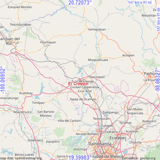
El Crestón GPS coordinates[2]
20° 3' 42.012" North, 99° 21' 59.004" West
| Map corner | latitude | longitude |
|---|---|---|
| Upper-left | 20.72073°, | -100.06952° |
| Center: | 20.06167°, | -99.36639° |
| Lower-right: | 19.39983°, | -98.66327° |
| Map W x H: | 146.9×146.9 km | = 91.3×91.3mi |
| max Lat: | 32.7° ⇑41.7% North |
| El Crestón: | 20.06167° |
| min Lat: | ⇓58.3% South 14.53588° |
| min Long | El Crestón | max Long |
| -117.105° | -99.36639° | -86.73105° |
| W 44.9%⇐ | ⇒55.1% E |
Elevation
Elevation of El Crestón is 2070 m = 6791 ft, and this is 816.3 m = 2678 ft above average elevation for this country.
| Max E: |
3497 m = 11473 ft | 22.9% |
| El Crestón | 2070 m 6791 ft | |
| Avg. | 1253.7 m = 4113 ft | |
Min E: |
-1 m = -3 ft | 77.1% |
See also: Mexico elevation on elevation.city.
Geographical zone
El Crestón is located in North Torrid zone (between Equator and Tropic of Cancer). Distance of this Northern Tropic circle is 375.3 km =233.2 mi to North.| Distance of | km | miles | from El Crestón |
|---|---|---|---|
| North Pole | 7776.4 | 4832 | to North |
| Arctic Circle | 5170.5 | 3212.8 | to North |
| Tropic Cancer | 375.3 | 233.2 | to North |
| Equator | 2230.6 | 1386 | to South |


Nearby cities:
15 places around El Crestón: (largest is in red/bold)
• Colonia Benito Juárez
5.7 km =3.5 mi,  28°
28°
• Colonia Nueva Santa María
7.3 km =4.5 mi,  167°
167°
• Colonia Sesenta y Dos
6.6 km =4.1 mi,  161°
161°
• El Llano
4.9 km =3 mi,  85°
85°
• Ignacio Zaragoza
7 km =4.3 mi,  137°
137°
• La Amistad
7.6 km =4.7 mi, 140°
• Michimaloya
4.7 km =2.9 mi,  314°
314°
• Nantzha
1 km =0.6 mi,  193°
193°
• Residencial Arboledas
6.8 km =4.2 mi, 87°
• San Andrés
1.6 km =1 mi,  240°
240°
• San Ildefonso
7.3 km =4.5 mi,  184°
184°
• San Marcos
4.7 km =2.9 mi, 136°
• Santa Ana Ahuehuepan
7.2 km =4.5 mi,  18°
18°
• Tula de Allende
2.6 km =1.6 mi,  115°
115°
• Xiteje de Zapata
4.6 km =2.9 mi,  329°
329°
Sources, notices
• [Note1] Compared only with cities in Mexico existing in our database
• [Src1] Map data: © OpenStreetMap contributors (CC-BY-SA)
• [Src2] Other city data from geonames.org with taken over terms of usage.
• [Src3] Geographical zone / Annual Mean Temperature by Robert A. Rohde @ Wikipedia
