Metepec geodata
Metepec (Hidalgo) is a seat of a second-order administrative division; located in Mexico in America/Mexico_City (GMT-6) time zone. With population of 2,090 people, there are 4173 cities with bigger population in this country. Compared to other cities in Mexico, 62.2% of cities are located further ↓South; 59.6% of cities are located further ←West and 80.8% of cities have lower elevation than Metepec. Note1


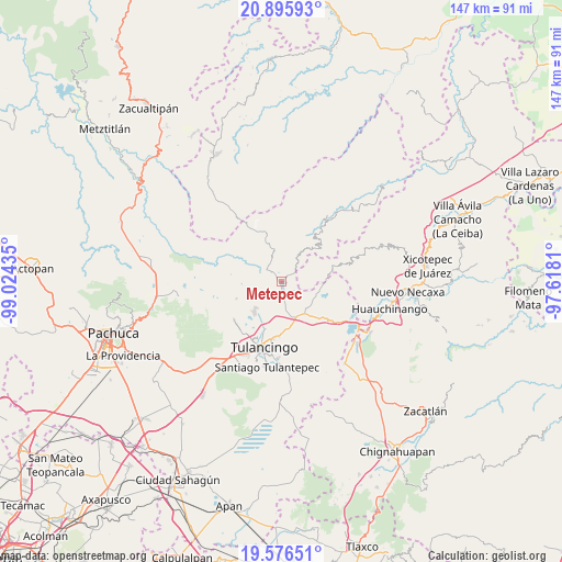
Metepec GPS coordinates[2]
20° 14' 15.432" North, 98° 19' 16.392" West
| Map corner | latitude | longitude |
|---|---|---|
| Upper-left | 20.89593°, | -99.02435° |
| Center: | 20.23762°, | -98.32122° |
| Lower-right: | 19.57651°, | -97.6181° |
| Map W x H: | 146.7×146.7 km | = 91.2×91.2mi |
| max Lat: | 32.7° ⇑37.8% North |
| Metepec: | 20.23762° |
| min Lat: | ⇓62.2% South 14.53588° |
| min Long | Metepec | max Long |
| -117.105° | -98.32122° | -86.73105° |
| W 59.6%⇐ | ⇒40.4% E |
Elevation
Elevation of Metepec is 2159 m = 7083 ft, and this is 905.3 m = 2970 ft above average elevation for this country.
| Max E: |
3497 m = 11473 ft | 19.2% |
| Metepec | 2159 m 7083 ft | |
| Avg. | 1253.7 m = 4113 ft | |
Min E: |
-1 m = -3 ft | 80.8% |
See also: Mexico elevation on elevation.city.
Geographical zone
Metepec is located in North Torrid zone (between Equator and Tropic of Cancer). Distance of this Northern Tropic circle is 355.7 km =221 mi to North.| Distance of | km | miles | from Metepec |
|---|---|---|---|
| North Pole | 7756.8 | 4819.9 | to North |
| Arctic Circle | 5151 | 3200.7 | to North |
| Tropic Cancer | 355.7 | 221 | to North |
| Equator | 2250.2 | 1398.2 | to South |


Nearby cities:
15 places around Metepec: (largest is in red/bold)
• Amapoloa
10.2 km =6.3 mi,  85°
85°
• El Acocul
5.5 km =3.4 mi,  251°
251°
• Estación de Apulco
6 km =3.7 mi,  333°
333°
• Ferrería de Apulco
7.6 km =4.7 mi,  341°
341°
• La Cruz de Tenango
7 km =4.3 mi,  44°
44°
• La Magdalena
5.2 km =3.2 mi,  65°
65°
• La Victoria
3.5 km =2.2 mi,  57°
57°
• Palo Gordo
2.9 km =1.8 mi,  147°
147°
• San Mateo
9.9 km =6.2 mi,  128°
128°
• San Nicolás Cebolletas (Cebolletas)
8.9 km =5.5 mi,  195°
195°
• San Pedro Tlachichilco
10.4 km =6.5 mi, 145°
• Santa Ana Hueytlalpan
7 km =4.3 mi,  172°
172°
• Tonalixco
6.9 km =4.3 mi,  95°
95°
• Vicente Guerrero
8.5 km =5.3 mi,  244°
244°
• Zacacuautla
10 km =6.2 mi, 104°
Sources, notices
• [Note1] Compared only with cities in Mexico existing in our database
• [Src1] Map data: © OpenStreetMap contributors (CC-BY-SA)
• [Src2] Other city data from geonames.org with taken over terms of usage.
• [Src3] Geographical zone / Annual Mean Temperature by Robert A. Rohde @ Wikipedia
