Palo Gordo geodata
Palo Gordo (Hidalgo) is a populated place; located in Mexico in America/Mexico_City (GMT-6) time zone. With population of 843 people, there are 10377 cities with bigger population in this country. Compared to other cities in Mexico, 61.7% of cities are located further ↓South; 59.8% of cities are located further ←West and 81.4% of cities have lower elevation than Palo Gordo. Note1


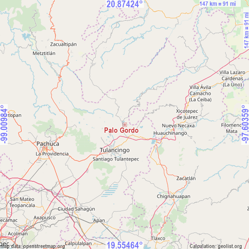
Palo Gordo GPS coordinates[2]
20° 12' 57.024" North, 98° 18' 24.156" West
| Map corner | latitude | longitude |
|---|---|---|
| Upper-left | 20.87424°, | -99.00984° |
| Center: | 20.21584°, | -98.30671° |
| Lower-right: | 19.55464°, | -97.60359° |
| Map W x H: | 146.7×146.7 km | = 91.2×91.2mi |
| max Lat: | 32.7° ⇑38.3% North |
| Palo Gordo: | 20.21584° |
| min Lat: | ⇓61.7% South 14.53588° |
| min Long | Palo Gordo | max Long |
| -117.105° | -98.30671° | -86.73105° |
| W 59.8%⇐ | ⇒40.2% E |
Elevation
Elevation of Palo Gordo is 2173 m = 7129 ft, and this is 919.3 m = 3016 ft above average elevation for this country.
| Max E: |
3497 m = 11473 ft | 18.6% |
| Palo Gordo | 2173 m 7129 ft | |
| Avg. | 1253.7 m = 4113 ft | |
Min E: |
-1 m = -3 ft | 81.4% |
See also: Mexico elevation on elevation.city.
Geographical zone
Palo Gordo is located in North Torrid zone (between Equator and Tropic of Cancer). Distance of this Northern Tropic circle is 358.1 km =222.5 mi to North.| Distance of | km | miles | from Palo Gordo |
|---|---|---|---|
| North Pole | 7759.3 | 4821.4 | to North |
| Arctic Circle | 5153.4 | 3202.2 | to North |
| Tropic Cancer | 358.1 | 222.5 | to North |
| Equator | 2247.8 | 1396.7 | to South |


Nearby cities:
15 places around Palo Gordo: (largest is in red/bold)
• El Acocul
6.8 km =4.2 mi,  276°
276°
• Estación de Apulco
8.9 km =5.5 mi,  331°
331°
• La Cruz de Tenango
8.2 km =5.1 mi,  24°
24°
• La Magdalena
5.6 km =3.5 mi,  35°
35°
• La Victoria
4.5 km =2.8 mi, 18°
• Metepec
2.9 km =1.8 mi, 327°
• Parque Urbano Napateco
8.9 km =5.5 mi,  203°
203°
• San Mateo
7.3 km =4.5 mi,  120°
120°
• San Nicolás Cebolletas (Cebolletas)
7.3 km =4.5 mi,  212°
212°
• San Pedro Tlachichilco
7.5 km =4.7 mi,  143°
143°
• Santa Ana Hueytlalpan
4.6 km =2.9 mi,  187°
187°
• Santa María Asunción
7.7 km =4.8 mi,  150°
150°
• Tepaltzingo
9 km =5.6 mi,  162°
162°
• Tonalixco
5.6 km =3.5 mi,  71°
71°
• Zacacuautla
8.1 km =5 mi,  90°
90°
Sources, notices
• [Note1] Compared only with cities in Mexico existing in our database
• [Src1] Map data: © OpenStreetMap contributors (CC-BY-SA)
• [Src2] Other city data from geonames.org with taken over terms of usage.
• [Src3] Geographical zone / Annual Mean Temperature by Robert A. Rohde @ Wikipedia
