Amamaloya geodata
Amamaloya (Veracruz) is a populated place; located in Mexico in America/Mexico_City (GMT-6) time zone. With population of 596 people, there are 14429 cities with bigger population in this country. Compared to other cities in Mexico, 76.9% of cities are located further ↑North; 85% of cities are located further ←West and 79.3% of cities have higher elevation than Amamaloya. Note1


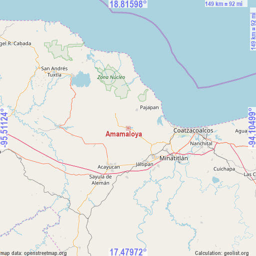
Amamaloya GPS coordinates[2]
18° 8' 56.868" North, 94° 48' 29.196" West
| Map corner | latitude | longitude |
|---|---|---|
| Upper-left | 18.81598°, | -95.51124° |
| Center: | 18.14913°, | -94.80811° |
| Lower-right: | 17.47972°, | -94.10499° |
| Map W x H: | 148.6×148.6 km | = 92.3×92.3mi |
| max Lat: | 32.7° ⇑76.9% North |
| Amamaloya: | 18.14913° |
| min Lat: | ⇓23.1% South 14.53588° |
| min Long | Amamaloya | max Long |
| -117.105° | -94.80811° | -86.73105° |
| W 85%⇐ | ⇒15% E |
Elevation
Elevation of Amamaloya is 105 m = 344 ft, and this is 1148.7 m = 3769 ft below average elevation for this country.
| Max E: |
3497 m = 11473 ft | 79.3% |
| Avg. | 1253.7 m = 4113 ft | |
| Amamaloya | 105 m = 344 ft | |
Min E: |
-1 m = -3 ft | 20.7% |
See also: Mexico elevation on elevation.city.
Geographical zone
Amamaloya is located in North Torrid zone (between Equator and Tropic of Cancer). Distance of this Northern Tropic circle is 587.9 km =365.3 mi to North.| Distance of | km | miles | from Amamaloya |
|---|---|---|---|
| North Pole | 7989.1 | 4964.2 | to North |
| Arctic Circle | 5383.2 | 3345 | to North |
| Tropic Cancer | 587.9 | 365.3 | to North |
| Equator | 2018 | 1253.9 | to South |


Nearby cities:
15 places around Amamaloya: (largest is in red/bold)
• Agua Fría
12.6 km =7.8 mi,  146°
146°
• Cerro de la Palma
3.4 km =2.1 mi,  299°
299°
• Cuilonia Nuevo
11.3 km =7 mi,  273°
273°
• El Naranjo
4.1 km =2.5 mi,  109°
109°
• Huazuntlán
1.8 km =1.1 mi,  62°
62°
• Ixhuapán
3.2 km =2 mi,  18°
18°
• La Estribera
9.2 km =5.7 mi,  247°
247°
• Las Palomas (Bajo Paloma)
9.8 km =6.1 mi, 268°
• Mecayapan
8.5 km =5.3 mi,  338°
338°
• Minzapan
8.6 km =5.3 mi,  97°
97°
• Saltillo
4.9 km =3 mi,  282°
282°
• San Andrés Chamilpa
8 km =5 mi,  217°
217°
• Soteapan
11.7 km =7.3 mi,  323°
323°
• Tatahuicapan
11.9 km =7.4 mi, 24°
• Tonalapa
1.6 km =1 mi,  89°
89°
Sources, notices
• [Note1] Compared only with cities in Mexico existing in our database
• [Src1] Map data: © OpenStreetMap contributors (CC-BY-SA)
• [Src2] Other city data from geonames.org with taken over terms of usage.
• [Src3] Geographical zone / Annual Mean Temperature by Robert A. Rohde @ Wikipedia
