San Miguel Mecatepec geodata
San Miguel Mecatepec (Veracruz) is a populated place; located in Mexico in America/Mexico_City (GMT-6) time zone. With population of 2,197 people, there are 3998 cities with bigger population in this country. Compared to other cities in Mexico, 68.4% of cities are located further ↓South; 69.6% of cities are located further ←West and 83.3% of cities have higher elevation than San Miguel Mecatepec. Note1


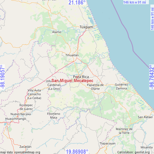
San Miguel Mecatepec GPS coordinates[2]
20° 31' 44.256" North, 97° 29' 14.784" West
| Map corner | latitude | longitude |
|---|---|---|
| Upper-left | 21.186°, | -98.19057° |
| Center: | 20.52896°, | -97.48744° |
| Lower-right: | 19.86908°, | -96.78432° |
| Map W x H: | 146.4×146.4 km | = 91×91mi |
| max Lat: | 32.7° ⇑31.6% North |
| San Miguel Mecatepec: | 20.52896° |
| min Lat: | ⇓68.4% South 14.53588° |
| min Long | San Miguel Meca | max Long |
| -117.105° | -97.48744° | -86.73105° |
| W 69.6%⇐ | ⇒30.4% E |
Elevation
Elevation of San Miguel Mecatepec is 58 m = 190 ft, and this is 1195.7 m = 3923 ft below average elevation for this country.
| Max E: |
3497 m = 11473 ft | 83.3% |
| Avg. | 1253.7 m = 4113 ft | |
| San Miguel Mecatepec | 58 m = 190 ft | |
Min E: |
-1 m = -3 ft | 16.7% |
See also: Mexico elevation on elevation.city.
Geographical zone
San Miguel Mecatepec is located in North Torrid zone (between Equator and Tropic of Cancer). Distance of this Northern Tropic circle is 323.3 km =200.9 mi to North.| Distance of | km | miles | from San Miguel Mecatepec |
|---|---|---|---|
| North Pole | 7724.5 | 4799.8 | to North |
| Arctic Circle | 5118.6 | 3180.5 | to North |
| Tropic Cancer | 323.3 | 200.9 | to North |
| Equator | 2282.6 | 1418.3 | to South |


Nearby cities:
15 places around San Miguel Mecatepec: (largest is in red/bold)
• Arroyo del Maíz Uno
7.6 km =4.7 mi,  83°
83°
• Coatzintla
5.1 km =3.2 mi,  156°
156°
• Corralillos
6.5 km =4 mi,  217°
217°
• Emiliano Zapata
4.5 km =2.8 mi,  298°
298°
• Escolín de Olarte
7.5 km =4.7 mi,  116°
116°
• La Laja
5.2 km =3.2 mi,  197°
197°
• Miguel Hidalgo
3.1 km =1.9 mi,  330°
330°
• Plan de Ayala
2.8 km =1.7 mi,  37°
37°
• Poza Rica de Hidalgo
3 km =1.9 mi, 80°
• Rancho Nuevo
6.9 km =4.3 mi,  23°
23°
• Ricardo Flores Magón
1.8 km =1.1 mi,  205°
205°
• Totolapa
3.4 km =2.1 mi, 19°
• Troncones y Potrerillos
5.9 km =3.7 mi, 164°
• Villa de las Flores
7.7 km =4.8 mi,  46°
46°
• Zacate Colorado
5.2 km =3.2 mi,  227°
227°
Sources, notices
• [Note1] Compared only with cities in Mexico existing in our database
• [Src1] Map data: © OpenStreetMap contributors (CC-BY-SA)
• [Src2] Other city data from geonames.org with taken over terms of usage.
• [Src3] Geographical zone / Annual Mean Temperature by Robert A. Rohde @ Wikipedia
