Coatzintla geodata
Coatzintla (Veracruz) is a seat of a second-order administrative division; located in Mexico in America/Mexico_City (GMT-6) time zone. With population of 34,036 people, there are 301 cities with bigger population in this country. Compared to other cities in Mexico, 67.5% of cities are located further ↓South; 69.9% of cities are located further ←West and 81.4% of cities have higher elevation than Coatzintla. Note1


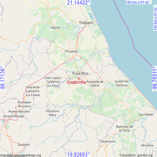
Coatzintla GPS coordinates[2]
20° 29' 13.164" North, 97° 28' 5.628" West
| Map corner | latitude | longitude |
|---|---|---|
| Upper-left | 21.14422°, | -98.17136° |
| Center: | 20.48699°, | -97.46823° |
| Lower-right: | 19.82693°, | -96.76511° |
| Map W x H: | 146.5×146.5 km | = 91×91mi |
| max Lat: | 32.7° ⇑32.5% North |
| Coatzintla: | 20.48699° |
| min Lat: | ⇓67.5% South 14.53588° |
| min Long | Coatzintla | max Long |
| -117.105° | -97.46823° | -86.73105° |
| W 69.9%⇐ | ⇒30.1% E |
Elevation
Elevation of Coatzintla is 77 m = 253 ft, and this is 1176.7 m = 3861 ft below average elevation for this country.
| Max E: |
3497 m = 11473 ft | 81.4% |
| Avg. | 1253.7 m = 4113 ft | |
| Coatzintla | 77 m = 253 ft | |
Min E: |
-1 m = -3 ft | 18.6% |
See also: Mexico elevation on elevation.city.
Geographical zone
Coatzintla is located in North Torrid zone (between Equator and Tropic of Cancer). Distance of this Northern Tropic circle is 328 km =203.8 mi to North.| Distance of | km | miles | from Coatzintla |
|---|---|---|---|
| North Pole | 7729.1 | 4802.6 | to North |
| Arctic Circle | 5123.2 | 3183.4 | to North |
| Tropic Cancer | 328 | 203.8 | to North |
| Equator | 2277.9 | 1415.4 | to South |


Nearby cities:
15 places around Coatzintla: (largest is in red/bold)
• Arroyo del Maíz Uno
7.8 km =4.8 mi,  44°
44°
• Corralillos
6 km =3.7 mi,  265°
265°
• El Mollejon
8.5 km =5.3 mi, 44°
• Escolín de Olarte
4.8 km =3 mi,  74°
74°
• La Laguna
5.6 km =3.5 mi,  152°
152°
• La Laja
3.5 km =2.2 mi, 265°
• Manuel María Contreras
4.8 km =3 mi,  199°
199°
• Miguel Hidalgo
8.2 km =5.1 mi,  334°
334°
• Plan de Ayala
6.9 km =4.3 mi,  357°
357°
• Poza Rica de Hidalgo
5.2 km =3.2 mi,  10°
10°
• Ricardo Flores Magón
4.1 km =2.5 mi,  317°
317°
• San Miguel Mecatepec
5.1 km =3.2 mi,  336°
336°
• Totolapa
7.9 km =4.9 mi,  353°
353°
• Troncones y Potrerillos
1.1 km =0.7 mi, 201°
• Zacate Colorado
5.9 km =3.7 mi,  281°
281°
Sources, notices
• [Note1] Compared only with cities in Mexico existing in our database
• [Src1] Map data: © OpenStreetMap contributors (CC-BY-SA)
• [Src2] Other city data from geonames.org with taken over terms of usage.
• [Src3] Geographical zone / Annual Mean Temperature by Robert A. Rohde @ Wikipedia
