Rancho Nuevo geodata
Rancho Nuevo (Veracruz) is a populated place; located in Mexico in America/Mexico_City (GMT-6) time zone. With population of 996 people, there are 8744 cities with bigger population in this country. Compared to other cities in Mexico, 69.7% of cities are located further ↓South; 69.9% of cities are located further ←West and 83.6% of cities have higher elevation than Rancho Nuevo. Note1


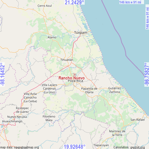
Rancho Nuevo GPS coordinates[2]
20° 35' 9.996" North, 97° 27' 41.004" West
| Map corner | latitude | longitude |
|---|---|---|
| Upper-left | 21.2429°, | -98.16452° |
| Center: | 20.58611°, | -97.46139° |
| Lower-right: | 19.92648°, | -96.75827° |
| Map W x H: | 146.4×146.4 km | = 91×91mi |
| max Lat: | 32.7° ⇑30.3% North |
| Rancho Nuevo: | 20.58611° |
| min Lat: | ⇓69.7% South 14.53588° |
| min Long | Rancho Nuevo | max Long |
| -117.105° | -97.46139° | -86.73105° |
| W 69.9%⇐ | ⇒30.1% E |
Elevation
Elevation of Rancho Nuevo is 54 m = 177 ft, and this is 1199.7 m = 3936 ft below average elevation for this country.
| Max E: |
3497 m = 11473 ft | 83.6% |
| Avg. | 1253.7 m = 4113 ft | |
| Rancho Nuevo | 54 m = 177 ft | |
Min E: |
-1 m = -3 ft | 16.4% |
See also: Mexico elevation on elevation.city.
Geographical zone
Rancho Nuevo is located in North Torrid zone (between Equator and Tropic of Cancer). Distance of this Northern Tropic circle is 317 km =197 mi to North.| Distance of | km | miles | from Rancho Nuevo |
|---|---|---|---|
| North Pole | 7718.1 | 4795.8 | to North |
| Arctic Circle | 5112.2 | 3176.6 | to North |
| Tropic Cancer | 317 | 197 | to North |
| Equator | 2289 | 1422.3 | to South |


Nearby cities:
15 places around Rancho Nuevo: (largest is in red/bold)
• Colonia las Arboledas
3.9 km =2.4 mi,  80°
80°
• El Palmar
4 km =2.5 mi,  55°
55°
• El Águila
5 km =3.1 mi,  6°
6°
• Fraccionamiento la Florida
3.4 km =2.1 mi,  88°
88°
• La Isla (Kilómetro 10)
4.8 km =3 mi,  300°
300°
• La Isla Km 10
4.6 km =2.9 mi, 300°
• La Victoria (Kilómetro 47)
4.2 km =2.6 mi,  73°
73°
• Miguel Hidalgo
5.6 km =3.5 mi,  229°
229°
• Nuevo Progreso
6 km =3.7 mi,  306°
306°
• Plan de Ayala
4.3 km =2.7 mi,  193°
193°
• Poza Rica de Hidalgo
5.9 km =3.7 mi,  178°
178°
• Residencial Tajín
4.8 km =3 mi, 73°
• Totolapa
3.5 km =2.2 mi,  206°
206°
• Villa de las Flores
3.1 km =1.9 mi,  110°
110°
• Úrsulo Galván
3 km =1.9 mi,  51°
51°
Sources, notices
• [Note1] Compared only with cities in Mexico existing in our database
• [Src1] Map data: © OpenStreetMap contributors (CC-BY-SA)
• [Src2] Other city data from geonames.org with taken over terms of usage.
• [Src3] Geographical zone / Annual Mean Temperature by Robert A. Rohde @ Wikipedia
