Escolín de Olarte geodata
Escolín de Olarte (Veracruz) is a populated place; located in Mexico in America/Mexico_City (GMT-6) time zone. With population of 1,055 people, there are 8271 cities with bigger population in this country. Compared to other cities in Mexico, 67.7% of cities are located further ↓South; 70.3% of cities are located further ←West and 77.6% of cities have higher elevation than Escolín de Olarte. Note1


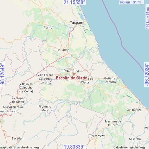
Escolín de Olarte GPS coordinates[2]
20° 29' 54.24" North, 97° 25' 24.096" West
| Map corner | latitude | longitude |
|---|---|---|
| Upper-left | 21.15558°, | -98.12649° |
| Center: | 20.4984°, | -97.42336° |
| Lower-right: | 19.83839°, | -96.72024° |
| Map W x H: | 146.5×146.5 km | = 91×91mi |
| max Lat: | 32.7° ⇑32.3% North |
| Escolín de Olarte: | 20.4984° |
| min Lat: | ⇓67.7% South 14.53588° |
| min Long | Escolín de Ola | max Long |
| -117.105° | -97.42336° | -86.73105° |
| W 70.3%⇐ | ⇒29.7% E |
Elevation
Elevation of Escolín de Olarte is 139 m = 456 ft, and this is 1114.7 m = 3657 ft below average elevation for this country.
| Max E: |
3497 m = 11473 ft | 77.6% |
| Avg. | 1253.7 m = 4113 ft | |
| Escolín de Olarte | 139 m = 456 ft | |
Min E: |
-1 m = -3 ft | 22.4% |
See also: Mexico elevation on elevation.city.
Geographical zone
Escolín de Olarte is located in North Torrid zone (between Equator and Tropic of Cancer). Distance of this Northern Tropic circle is 326.7 km =203 mi to North.| Distance of | km | miles | from Escolín de Olarte |
|---|---|---|---|
| North Pole | 7727.9 | 4801.9 | to North |
| Arctic Circle | 5122 | 3182.7 | to North |
| Tropic Cancer | 326.7 | 203 | to North |
| Equator | 2279.2 | 1416.2 | to South |


Nearby cities:
15 places around Escolín de Olarte: (largest is in red/bold)
• Arroyo del Maíz Uno
4.3 km =2.7 mi,  11°
11°
• Coatzintla
4.8 km =3 mi,  254°
254°
• Donato Márquez Azuara
6.9 km =4.3 mi,  64°
64°
• El Cabellal
8.4 km =5.2 mi,  50°
50°
• El Mollejon
5 km =3.1 mi, 14°
• La Grandeza
4.7 km =2.9 mi, 62°
• La Laguna
6.5 km =4 mi,  198°
198°
• La Laja
8.3 km =5.2 mi,  259°
259°
• Manuel María Contreras
8.5 km =5.3 mi,  227°
227°
• Plan de Ayala
7.5 km =4.7 mi,  318°
318°
• Poza Rica de Hidalgo
5.4 km =3.4 mi, 315°
• Reforma Escolín
4.1 km =2.5 mi,  107°
107°
• Ricardo Flores Magón
7.7 km =4.8 mi,  283°
283°
• San Miguel Mecatepec
7.5 km =4.7 mi,  296°
296°
• Troncones y Potrerillos
5.6 km =3.5 mi, 245°
Sources, notices
• [Note1] Compared only with cities in Mexico existing in our database
• [Src1] Map data: © OpenStreetMap contributors (CC-BY-SA)
• [Src2] Other city data from geonames.org with taken over terms of usage.
• [Src3] Geographical zone / Annual Mean Temperature by Robert A. Rohde @ Wikipedia
