Mazatepec geodata
Mazatepec (Puebla) is a populated place; located in Mexico in America/Mexico_City (GMT-6) time zone. With population of 1,587 people, there are 5439 cities with bigger population in this country. Compared to other cities in Mexico, 57.3% of cities are located further ↓South; 70.4% of cities are located further ←West and 65.8% of cities have higher elevation than Mazatepec. Note1


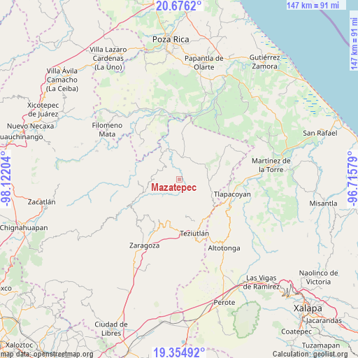
Mazatepec GPS coordinates[2]
20° 1' 1.02" North, 97° 25' 8.076" West
| Map corner | latitude | longitude |
|---|---|---|
| Upper-left | 20.6762°, | -98.12204° |
| Center: | 20.01695°, | -97.41891° |
| Lower-right: | 19.35492°, | -96.71579° |
| Map W x H: | 146.9×146.9 km | = 91.3×91.3mi |
| max Lat: | 32.7° ⇑42.7% North |
| Mazatepec: | 20.01695° |
| min Lat: | ⇓57.3% South 14.53588° |
| min Long | Mazatepec | max Long |
| -117.105° | -97.41891° | -86.73105° |
| W 70.4%⇐ | ⇒29.6% E |
Elevation
Elevation of Mazatepec is 645 m = 2116 ft, and this is 608.7 m = 1997 ft below average elevation for this country.
| Max E: |
3497 m = 11473 ft | 65.8% |
| Avg. | 1253.7 m = 4113 ft | |
| Mazatepec | 645 m = 2116 ft | |
Min E: |
-1 m = -3 ft | 34.2% |
See also: Mexico elevation on elevation.city.
Geographical zone
Mazatepec is located in North Torrid zone (between Equator and Tropic of Cancer). Distance of this Northern Tropic circle is 380.2 km =236.2 mi to North.| Distance of | km | miles | from Mazatepec |
|---|---|---|---|
| North Pole | 7781.4 | 4835.1 | to North |
| Arctic Circle | 5175.5 | 3215.9 | to North |
| Tropic Cancer | 380.2 | 236.2 | to North |
| Equator | 2225.7 | 1383 | to South |


Nearby cities:
15 places around Mazatepec: (largest is in red/bold)
• Ayotoxco de Guerrero
8.8 km =5.5 mi,  6°
6°
• Cuauhtamazaco
7.2 km =4.5 mi,  277°
277°
• Cuauhtapanaloyan
7.4 km =4.6 mi,  327°
327°
• El Progreso
5.7 km =3.5 mi,  87°
87°
• Ixtahuata
9.3 km =5.8 mi,  273°
273°
• Nectepec
2.8 km =1.7 mi,  303°
303°
• Pepexta
5.2 km =3.2 mi, 300°
• San Antonio Metzonapa
5.7 km =3.5 mi,  46°
46°
• Santiago Yancuictlalpan
7.4 km =4.6 mi,  311°
311°
• Tacuapan
9.5 km =5.9 mi,  320°
320°
• Tuzamapan Xiloxochico
8.6 km =5.3 mi, 301°
• Xalpantzingo
5.5 km =3.4 mi, 278°
• Xiloxochico de Rafael Ávila Camacho
8.2 km =5.1 mi,  293°
293°
• Yohualichan
10.1 km =6.3 mi, 299°
• Zacatipan
3 km =1.9 mi, 324°
Sources, notices
• [Note1] Compared only with cities in Mexico existing in our database
• [Src1] Map data: © OpenStreetMap contributors (CC-BY-SA)
• [Src2] Other city data from geonames.org with taken over terms of usage.
• [Src3] Geographical zone / Annual Mean Temperature by Robert A. Rohde @ Wikipedia
