Ayotoxco de Guerrero geodata
Ayotoxco de Guerrero (Puebla) is a seat of a second-order administrative division; located in Mexico in America/Mexico_City (GMT-6) time zone. With population of 2,911 people, there are 3061 cities with bigger population in this country. Compared to other cities in Mexico, 59.1% of cities are located further ↓South; 70.5% of cities are located further ←West and 72.7% of cities have higher elevation than Ayotoxco de Guerrero. Note1
Current local time in Ayotoxco de Guerrero:
06:48 AM, WednesdayDifference from your time zone: hours


Ayotoxco de Guerrero GPS coordinates[2]
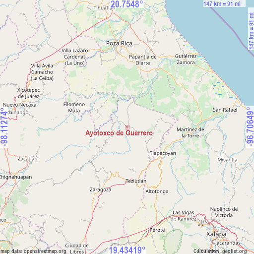
20° 5' 45.204" North, 97° 24' 34.596" West
| Map corner | latitude | longitude |
|---|---|---|
| Upper-left | 20.7548°, | -98.11274° |
| Center: | 20.09589°, | -97.40961° |
| Lower-right: | 19.43419°, | -96.70649° |
| Map W x H: | 146.8×146.8 km | = 91.2×91.2mi |
| max Lat: | 32.7° ⇑40.9% North |
| Ayotoxco de Guerrero: | 20.09589° |
| min Lat: | ⇓59.1% South 14.53588° |
| min Long | Ayotoxco de Gue | max Long |
| -117.105° | -97.40961° | -86.73105° |
| W 70.5%⇐ | ⇒29.5% E |
Elevation
Elevation of Ayotoxco de Guerrero is 303 m = 994 ft, and this is 950.7 m = 3119 ft below average elevation for this country.
| Max E: |
3497 m = 11473 ft | 72.7% |
| Avg. | 1253.7 m = 4113 ft | |
| Ayotoxco de Guerrero | 303 m = 994 ft | |
Min E: |
-1 m = -3 ft | 27.3% |
See also: Mexico elevation on elevation.city.
Geographical zone
Ayotoxco de Guerrero is located in North Torrid zone (between Equator and Tropic of Cancer). Distance of this Northern Tropic circle is 371.5 km =230.8 mi to North.| Distance of | km | miles | from Ayotoxco de Guerrero |
|---|---|---|---|
| North Pole | 7772.6 | 4829.7 | to North |
| Arctic Circle | 5166.7 | 3210.4 | to North |
| Tropic Cancer | 371.5 | 230.8 | to North |
| Equator | 2234.5 | 1388.5 | to South |


Nearby cities:
15 places around Ayotoxco de Guerrero: (largest is in red/bold)
• Buena Vista
5.8 km =3.6 mi,  307°
307°
• Cuauhtapanaloyan
5.6 km =3.5 mi,  242°
242°
• Gachupinate
2.3 km =1.4 mi,  17°
17°
• La Lima
7.4 km =4.6 mi,  2°
2°
• Mazatepec
8.8 km =5.5 mi,  186°
186°
• Nectepec
8 km =5 mi,  204°
204°
• Pepexta
8.2 km =5.1 mi,  221°
221°
• San Antonio Metzonapa
5.8 km =3.6 mi,  147°
147°
• San Antonio Rayón
7.9 km =4.9 mi,  283°
283°
• Santiago Yancuictlalpan
7.6 km =4.7 mi, 239°
• Tacuapan
7.2 km =4.5 mi,  258°
258°
• Tecpantzingo
6 km =3.7 mi, 275°
• Tenampulco
8.3 km =5.2 mi, 3°
• Tenexate
7.6 km =4.7 mi,  45°
45°
• Zacatipan
6.9 km =4.3 mi, 203°
Sources, notices
• [Note1] Compared only with cities in Mexico existing in our database
• [Src1] Map data: © OpenStreetMap contributors (CC-BY-SA)
• [Src2] Other city data from geonames.org with taken over terms of usage.
• [Src3] Geographical zone / Annual Mean Temperature by Robert A. Rohde @ Wikipedia
