Maravillas geodata
Maravillas (Puebla) is a populated place; located in Mexico in America/Mexico_City (GMT-6) time zone. With population of 870 people, there are 10041 cities with bigger population in this country. Compared to other cities in Mexico, 57.8% of cities are located further ↑North; 71.4% of cities are located further ←West and 92% of cities have lower elevation than Maravillas. Note1


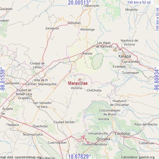
Maravillas GPS coordinates[2]
19° 20' 35.016" North, 97° 18' 44.856" West
| Map corner | latitude | longitude |
|---|---|---|
| Upper-left | 20.00513°, | -98.01559° |
| Center: | 19.34306°, | -97.31246° |
| Lower-right: | 18.67829°, | -96.60934° |
| Map W x H: | 147.5×147.5 km | = 91.7×91.7mi |
| max Lat: | 32.7° ⇑57.8% North |
| Maravillas: | 19.34306° |
| min Lat: | ⇓42.2% South 14.53588° |
| min Long | Maravillas | max Long |
| -117.105° | -97.31246° | -86.73105° |
| W 71.4%⇐ | ⇒28.6% E |
Elevation
Elevation of Maravillas is 2484 m = 8150 ft, and this is 1230.3 m = 4036 ft above average elevation for this country.
| Max E: |
3497 m = 11473 ft | 8% |
| Maravillas | 2484 m 8150 ft | |
| Avg. | 1253.7 m = 4113 ft | |
Min E: |
-1 m = -3 ft | 92% |
See also: Mexico elevation on elevation.city.
Geographical zone
Maravillas is located in North Torrid zone (between Equator and Tropic of Cancer). Distance of this Northern Tropic circle is 455.2 km =282.8 mi to North.| Distance of | km | miles | from Maravillas |
|---|---|---|---|
| North Pole | 7856.3 | 4881.7 | to North |
| Arctic Circle | 5250.4 | 3262.4 | to North |
| Tropic Cancer | 455.2 | 282.8 | to North |
| Equator | 2150.7 | 1336.4 | to South |


Nearby cities:
15 places around Maravillas: (largest is in red/bold)
• Altamirada
10.7 km =6.6 mi,  74°
74°
• Chichicuautla
10.1 km =6.3 mi,  301°
301°
• El Ciprés
11.5 km =7.1 mi, 74°
• El Progreso
5.3 km =3.3 mi,  27°
27°
• Francisco I. Madero (El Sabinal)
11.1 km =6.9 mi,  197°
197°
• González Ortega
4.4 km =2.7 mi,  90°
90°
• Guadalupe Victoria
6.6 km =4.1 mi,  208°
208°
• Hacienda Nueva (San Pedro el Águila)
10.5 km =6.5 mi,  264°
264°
• La Gloria
6.6 km =4.1 mi, 28°
• Pocitos
8.9 km =5.5 mi,  160°
160°
• Quechulac
5 km =3.1 mi,  311°
311°
• Saltillo
5.4 km =3.4 mi, 162°
• Tlanalapan
10.9 km =6.8 mi, 159°
• Xaltepec
6.2 km =3.9 mi, 312°
• Zalayeta (Alchichica y el Bordo)
11.3 km =7 mi, 312°
Sources, notices
• [Note1] Compared only with cities in Mexico existing in our database
• [Src1] Map data: © OpenStreetMap contributors (CC-BY-SA)
• [Src2] Other city data from geonames.org with taken over terms of usage.
• [Src3] Geographical zone / Annual Mean Temperature by Robert A. Rohde @ Wikipedia
