Guadalupe Victoria geodata
Guadalupe Victoria (Puebla) is a populated place; located in Mexico in America/Mexico_City (GMT-6) time zone. With population of 10,035 people, there are 951 cities with bigger population in this country. Compared to other cities in Mexico, 59% of cities are located further ↑North; 71.1% of cities are located further ←West and 91.1% of cities have lower elevation than Guadalupe Victoria. Note1


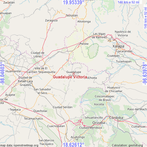
Guadalupe Victoria GPS coordinates[2]
19° 17' 27.96" North, 97° 20' 34.44" West
| Map corner | latitude | longitude |
|---|---|---|
| Upper-left | 19.95339°, | -98.04603° |
| Center: | 19.2911°, | -97.3429° |
| Lower-right: | 18.62612°, | -96.63978° |
| Map W x H: | 147.6×147.6 km | = 91.7×91.7mi |
| max Lat: | 32.7° ⇑59% North |
| Guadalupe Victoria: | 19.2911° |
| min Lat: | ⇓41% South 14.53588° |
| min Long | Guadalupe Victo | max Long |
| -117.105° | -97.3429° | -86.73105° |
| W 71.1%⇐ | ⇒28.9% E |
Elevation
Elevation of Guadalupe Victoria is 2445 m = 8022 ft, and this is 1191.3 m = 3908 ft above average elevation for this country.
| Max E: |
3497 m = 11473 ft | 8.9% |
| Guadalupe Victoria | 2445 m 8022 ft | |
| Avg. | 1253.7 m = 4113 ft | |
Min E: |
-1 m = -3 ft | 91.1% |
See also: Mexico elevation on elevation.city.
Geographical zone
Guadalupe Victoria is located in North Torrid zone (between Equator and Tropic of Cancer). Distance of this Northern Tropic circle is 460.9 km =286.4 mi to North.| Distance of | km | miles | from Guadalupe Victoria |
|---|---|---|---|
| North Pole | 7862.1 | 4885.3 | to North |
| Arctic Circle | 5256.2 | 3266.1 | to North |
| Tropic Cancer | 460.9 | 286.4 | to North |
| Equator | 2145 | 1332.8 | to South |


Nearby cities:
15 places around Guadalupe Victoria: (largest is in red/bold)
• Chichicuautla
12.3 km =7.6 mi,  334°
334°
• Cuauhtémoc
7.6 km =4.7 mi,  176°
176°
• El Progreso
11.9 km =7.4 mi,  28°
28°
• Francisco I. Madero (El Sabinal)
4.8 km =3 mi, 182°
• González Ortega
9.5 km =5.9 mi,  53°
53°
• Guadalupe Libertad
12.4 km =7.7 mi,  202°
202°
• Hacienda Nueva (San Pedro el Águila)
8.7 km =5.4 mi,  303°
303°
• Maravillas
6.6 km =4.1 mi, 28°
• Pocitos
6.7 km =4.2 mi,  113°
113°
• Quechulac
9.1 km =5.7 mi,  356°
356°
• Saltillo
4.9 km =3 mi,  83°
83°
• San José la Capilla
8.4 km =5.2 mi,  207°
207°
• Tlanalapan
8.3 km =5.2 mi,  122°
122°
• Vicente Guerrero
12.3 km =7.6 mi, 105°
• Xaltepec
10.1 km =6.3 mi,  352°
352°
Sources, notices
• [Note1] Compared only with cities in Mexico existing in our database
• [Src1] Map data: © OpenStreetMap contributors (CC-BY-SA)
• [Src2] Other city data from geonames.org with taken over terms of usage.
• [Src3] Geographical zone / Annual Mean Temperature by Robert A. Rohde @ Wikipedia
