La Concordia geodata
La Concordia (Chiapas) is a seat of a second-order administrative division; located in Mexico in America/Mexico_City (GMT-6) time zone. With population of 7,641 people, there are 1216 cities with bigger population in this country. Compared to other cities in Mexico, 96.8% of cities are located further ↑North; 90.6% of cities are located further ←West and 67.6% of cities have higher elevation than La Concordia. Note1


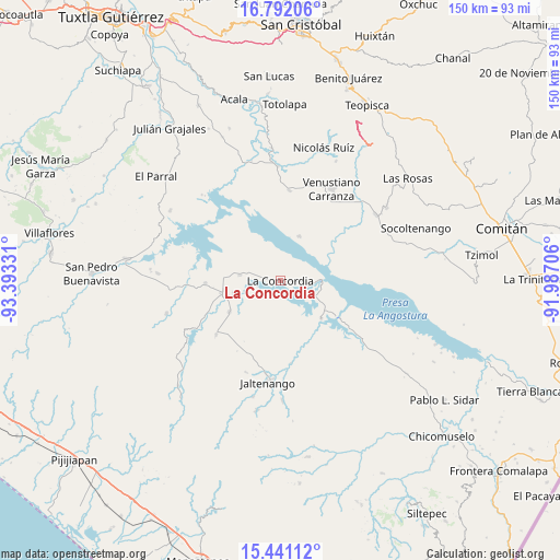
La Concordia GPS coordinates[2]
16° 7' 3.864" North, 92° 41' 24.648" West
| Map corner | latitude | longitude |
|---|---|---|
| Upper-left | 16.79206°, | -93.39331° |
| Center: | 16.11774°, | -92.69018° |
| Lower-right: | 15.44112°, | -91.98706° |
| Map W x H: | 150.2×150.2 km | = 93.3×93.3mi |
| max Lat: | 32.7° ⇑96.8% North |
| La Concordia: | 16.11774° |
| min Lat: | ⇓3.2% South 14.53588° |
| min Long | La Concordia | max Long |
| -117.105° | -92.69018° | -86.73105° |
| W 90.6%⇐ | ⇒9.4% E |
Elevation
Elevation of La Concordia is 549 m = 1801 ft, and this is 704.7 m = 2312 ft below average elevation for this country.
| Max E: |
3497 m = 11473 ft | 67.6% |
| Avg. | 1253.7 m = 4113 ft | |
| La Concordia | 549 m = 1801 ft | |
Min E: |
-1 m = -3 ft | 32.4% |
See also: Mexico elevation on elevation.city.
Geographical zone
La Concordia is located in North Torrid zone (between Equator and Tropic of Cancer). Distance of this Northern Tropic circle is 813.8 km =505.7 mi to North.| Distance of | km | miles | from La Concordia |
|---|---|---|---|
| North Pole | 8214.9 | 5104.5 | to North |
| Arctic Circle | 5609 | 3485.3 | to North |
| Tropic Cancer | 813.8 | 505.7 | to North |
| Equator | 1792.1 | 1113.6 | to South |


Nearby cities:
15 places around La Concordia: (largest is in red/bold)
• Benito Juárez
16.1 km =10 mi,  238°
238°
• Diamante de Echeverría
20.2 km =12.6 mi,  268°
268°
• Dolores Jaltenango
26.3 km =16.3 mi,  200°
200°
• El Ámbar (El Ámbar de Echeverría)
15.5 km =9.6 mi,  261°
261°
• Guadalupe Victoria
24.8 km =15.4 mi, 241°
• Ignacio Zaragoza
14.8 km =9.2 mi,  132°
132°
• Independencia
16.2 km =10.1 mi, 257°
• La Tigrilla
22.6 km =14 mi,  230°
230°
• Niños Héroes
7.3 km =4.5 mi,  98°
98°
• Nueva Libertad
13 km =8.1 mi, 256°
• Paraíso del Grijalva
13 km =8.1 mi,  22°
22°
• Plan de Agua Prieta
10.9 km =6.8 mi,  277°
277°
• Presidente Echeverría (Laja Tendida)
24.4 km =15.2 mi,  5°
5°
• Reforma
22.3 km =13.9 mi,  173°
173°
• San Nicolás
25.5 km =15.8 mi,  189°
189°
Sources, notices
• [Note1] Compared only with cities in Mexico existing in our database
• [Src1] Map data: © OpenStreetMap contributors (CC-BY-SA)
• [Src2] Other city data from geonames.org with taken over terms of usage.
• [Src3] Geographical zone / Annual Mean Temperature by Robert A. Rohde @ Wikipedia
