Nuevo Progreso geodata
Nuevo Progreso (Tamaulipas) is a populated place; located in Mexico in America/Monterrey (GMT-6) time zone. With population of 694 people, there are 12543 cities with bigger population in this country. Compared to other cities in Mexico, 88.3% of cities are located further ↓South; 64.2% of cities are located further ←West and 85.9% of cities have higher elevation than Nuevo Progreso. Note1


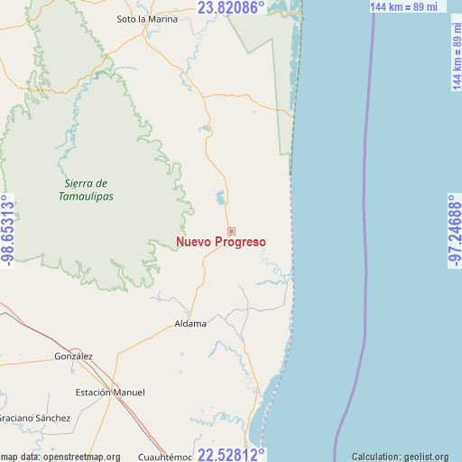
Nuevo Progreso GPS coordinates[2]
23° 10' 33.78" North, 97° 57' 0" West
| Map corner | latitude | longitude |
|---|---|---|
| Upper-left | 23.82086°, | -98.65313° |
| Center: | 23.17605°, | -97.95° |
| Lower-right: | 22.52812°, | -97.24688° |
| Map W x H: | 143.7×143.7 km | = 89.3×89.3mi |
| max Lat: | 32.7° ⇑11.7% North |
| Nuevo Progreso: | 23.17605° |
| min Lat: | ⇓88.3% South 14.53588° |
| min Long | Nuevo Progreso | max Long |
| -117.105° | -97.95° | -86.73105° |
| W 64.2%⇐ | ⇒35.8% E |
Elevation
Elevation of Nuevo Progreso is 39 m = 128 ft, and this is 1214.7 m = 3985 ft below average elevation for this country.
| Max E: |
3497 m = 11473 ft | 85.9% |
| Avg. | 1253.7 m = 4113 ft | |
| Nuevo Progreso | 39 m = 128 ft | |
Min E: |
-1 m = -3 ft | 14.1% |
See also: Mexico elevation on elevation.city.
Geographical zone
Nuevo Progreso is located in North Torrid zone (between Equator and Tropic of Cancer). Distance of this Northern Tropic circle is 29 km =18 mi to North.| Distance of | km | miles | from Nuevo Progreso |
|---|---|---|---|
| North Pole | 7430.1 | 4616.8 | to North |
| Arctic Circle | 4824.2 | 2997.6 | to North |
| Tropic Cancer | 29 | 18 | to North |
| Equator | 2576.9 | 1601.2 | to South |


Nearby cities:
15 places around Nuevo Progreso: (largest is in red/bold)
• Aldama
31.1 km =19.3 mi,  204°
204°
• Aquiles Serdán
68.1 km =42.3 mi,  176°
176°
• Barra el Tordo
22.9 km =14.2 mi,  127°
127°
• Cuauhtémoc
73.2 km =45.5 mi, 196°
• Esteros
75.1 km =46.7 mi,  193°
193°
• Francisco I. Madero
41.5 km =25.8 mi, 202°
• González
62.4 km =38.8 mi,  231°
231°
• Higinio Tanguma
47.5 km =29.5 mi,  220°
220°
• José María Luis Mora
64.1 km =39.8 mi, 188°
• La Pesca
70.1 km =43.6 mi,  14°
14°
• Lomas del Real
73.1 km =45.4 mi, 175°
• Miguel de la Madrid
70.5 km =43.8 mi,  16°
16°
• Santa Fe
65.7 km =40.8 mi, 228°
• Soto la Marina
70.9 km =44.1 mi,  338°
338°
• Ursulo Galván
62.7 km =39 mi, 217°
Sources, notices
• [Note1] Compared only with cities in Mexico existing in our database
• [Src1] Map data: © OpenStreetMap contributors (CC-BY-SA)
• [Src2] Other city data from geonames.org with taken over terms of usage.
• [Src3] Geographical zone / Annual Mean Temperature by Robert A. Rohde @ Wikipedia
