La Soledad geodata
La Soledad (Chiapas) is a populated place; located in Mexico in America/Mexico_City (GMT-6) time zone. With population of 951 people, there are 9161 cities with bigger population in this country. Compared to other cities in Mexico, 98.4% of cities are located further ↑North; 92% of cities are located further ←West and 51.3% of cities have higher elevation than La Soledad. Note1


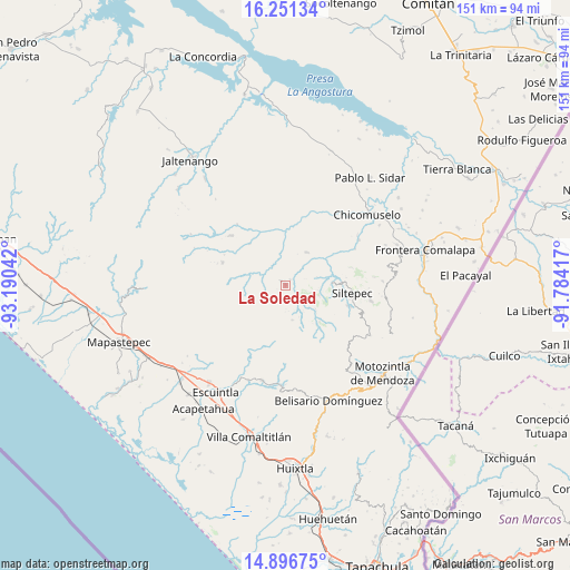
La Soledad GPS coordinates[2]
15° 34' 30.576" North, 92° 29' 14.244" West
| Map corner | latitude | longitude |
|---|---|---|
| Upper-left | 16.25134°, | -93.19042° |
| Center: | 15.57516°, | -92.48729° |
| Lower-right: | 14.89675°, | -91.78417° |
| Map W x H: | 150.6×150.6 km | = 93.6×93.6mi |
| max Lat: | 32.7° ⇑98.4% North |
| La Soledad: | 15.57516° |
| min Lat: | ⇓1.6% South 14.53588° |
| min Long | La Soledad | max Long |
| -117.105° | -92.48729° | -86.73105° |
| W 92%⇐ | ⇒8% E |
Elevation
Elevation of La Soledad is 1365 m = 4478 ft, and this is 111.3 m = 365 ft above average elevation for this country.
| Max E: |
3497 m = 11473 ft | 51.3% |
| La Soledad | 1365 m 4478 ft | |
| Avg. | 1253.7 m = 4113 ft | |
Min E: |
-1 m = -3 ft | 48.7% |
See also: Mexico elevation on elevation.city.
Geographical zone
La Soledad is located in North Torrid zone (between Equator and Tropic of Cancer). Distance of this Northern Tropic circle is 874.1 km =543.1 mi to North.| Distance of | km | miles | from La Soledad |
|---|---|---|---|
| North Pole | 8275.3 | 5142 | to North |
| Arctic Circle | 5669.4 | 3522.8 | to North |
| Tropic Cancer | 874.1 | 543.1 | to North |
| Equator | 1731.8 | 1076.1 | to South |


Nearby cities:
15 places around La Soledad: (largest is in red/bold)
• Angel Díaz
9.4 km =5.8 mi,  107°
107°
• Buenos Aires
1.7 km =1.1 mi,  313°
313°
• Capitán Luis A. Vidal
15.5 km =9.6 mi,  280°
280°
• Honduras
1.9 km =1.2 mi,  35°
35°
• Laguna del Cofre
17.5 km =10.9 mi,  289°
289°
• Las Cruces
17.2 km =10.7 mi,  101°
101°
• Las Delicias
6.7 km =4.2 mi,  345°
345°
• Las Moras
6.5 km =4 mi, 105°
• Miguel Alemán
17.2 km =10.7 mi,  357°
357°
• Monte Sinaí
18.1 km =11.2 mi,  45°
45°
• Nueva Independencia
14.4 km =8.9 mi,  319°
319°
• Pablo Galeana
5.7 km =3.5 mi,  265°
265°
• Santo Domingo (La Cascada)
13.3 km =8.3 mi,  138°
138°
• Siltepec
17.7 km =11 mi, 96°
• Toquián Grande
15.1 km =9.4 mi, 109°
Sources, notices
• [Note1] Compared only with cities in Mexico existing in our database
• [Src1] Map data: © OpenStreetMap contributors (CC-BY-SA)
• [Src2] Other city data from geonames.org with taken over terms of usage.
• [Src3] Geographical zone / Annual Mean Temperature by Robert A. Rohde @ Wikipedia
