Joachín geodata
Joachín (Veracruz) is a populated place; located in Mexico in America/Mexico_City (GMT-6) time zone. With population of 2,621 people, there are 3379 cities with bigger population in this country. Compared to other cities in Mexico, 70.9% of cities are located further ↑North; 81.2% of cities are located further ←West and 84.6% of cities have higher elevation than Joachín. Note1


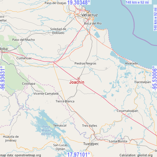
Joachín GPS coordinates[2]
18° 38' 18.78" North, 96° 13' 59.448" West
| Map corner | latitude | longitude |
|---|---|---|
| Upper-left | 19.30348°, | -96.93631° |
| Center: | 18.63855°, | -96.23318° |
| Lower-right: | 17.97101°, | -95.53006° |
| Map W x H: | 148.2×148.2 km | = 92.1×92.1mi |
| max Lat: | 32.7° ⇑70.9% North |
| Joachín: | 18.63855° |
| min Lat: | ⇓29.1% South 14.53588° |
| min Long | Joachín | max Long |
| -117.105° | -96.23318° | -86.73105° |
| W 81.2%⇐ | ⇒18.8% E |
Elevation
Elevation of Joachín is 47 m = 154 ft, and this is 1206.7 m = 3959 ft below average elevation for this country.
| Max E: |
3497 m = 11473 ft | 84.6% |
| Avg. | 1253.7 m = 4113 ft | |
| Joachín | 47 m = 154 ft | |
Min E: |
-1 m = -3 ft | 15.4% |
See also: Mexico elevation on elevation.city.
Geographical zone
Joachín is located in North Torrid zone (between Equator and Tropic of Cancer). Distance of this Northern Tropic circle is 533.5 km =331.5 mi to North.| Distance of | km | miles | from Joachín |
|---|---|---|---|
| North Pole | 7934.6 | 4930.3 | to North |
| Arctic Circle | 5328.8 | 3311.2 | to North |
| Tropic Cancer | 533.5 | 331.5 | to North |
| Equator | 2072.4 | 1287.7 | to South |


Nearby cities:
15 places around Joachín: (largest is in red/bold)
• Cuyucuenda
16.5 km =10.3 mi,  345°
345°
• El Amate
19.1 km =11.9 mi,  235°
235°
• El Cocuite
18 km =11.2 mi,  60°
60°
• El Contento
3.8 km =2.4 mi,  104°
104°
• El Jícaro
10.6 km =6.6 mi,  190°
190°
• El Moral
15.9 km =9.9 mi,  119°
119°
• El Zapote
18.5 km =11.5 mi,  38°
38°
• La Isla
9.8 km =6.1 mi, 116°
• Los Mangos
14.2 km =8.8 mi,  266°
266°
• Mata de Lázaro
14.1 km =8.8 mi,  0°
0°
• Paso Carretas
11.3 km =7 mi, 63°
• Paso Coyote
10 km =6.2 mi,  259°
259°
• Piedras Negras
16 km =9.9 mi,  23°
23°
• Rodríguez Tejeda
19.2 km =11.9 mi, 267°
• Serenilla de Abajo
18.6 km =11.6 mi,  245°
245°
Sources, notices
• [Note1] Compared only with cities in Mexico existing in our database
• [Src1] Map data: © OpenStreetMap contributors (CC-BY-SA)
• [Src2] Other city data from geonames.org with taken over terms of usage.
• [Src3] Geographical zone / Annual Mean Temperature by Robert A. Rohde @ Wikipedia
