El Jícaro geodata
El Jícaro (Veracruz) is a populated place; located in Mexico in America/Mexico_City (GMT-6) time zone. With population of 581 people, there are 14753 cities with bigger population in this country. Compared to other cities in Mexico, 72.1% of cities are located further ↑North; 81.1% of cities are located further ←West and 84.3% of cities have higher elevation than El Jícaro. Note1


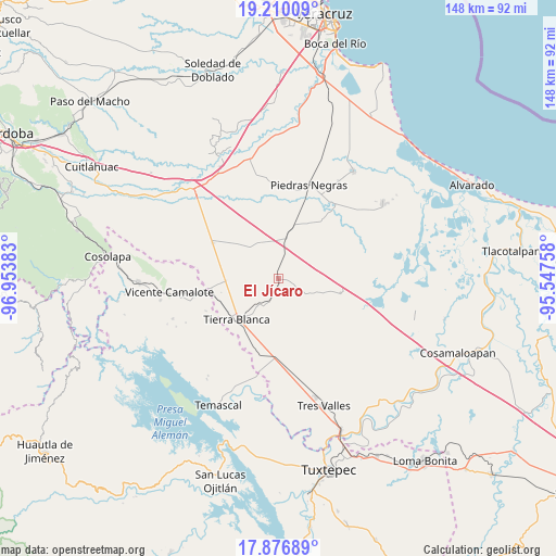
El Jícaro GPS coordinates[2]
18° 32' 41.244" North, 96° 15' 2.52" West
| Map corner | latitude | longitude |
|---|---|---|
| Upper-left | 19.21009°, | -96.95383° |
| Center: | 18.54479°, | -96.2507° |
| Lower-right: | 17.87689°, | -95.54758° |
| Map W x H: | 148.2×148.2 km | = 92.1×92.1mi |
| max Lat: | 32.7° ⇑72.1% North |
| El Jícaro: | 18.54479° |
| min Lat: | ⇓27.9% South 14.53588° |
| min Long | El Jícaro | max Long |
| -117.105° | -96.2507° | -86.73105° |
| W 81.1%⇐ | ⇒18.9% E |
Elevation
Elevation of El Jícaro is 50 m = 164 ft, and this is 1203.7 m = 3949 ft below average elevation for this country.
| Max E: |
3497 m = 11473 ft | 84.3% |
| Avg. | 1253.7 m = 4113 ft | |
| El Jícaro | 50 m = 164 ft | |
Min E: |
-1 m = -3 ft | 15.7% |
See also: Mexico elevation on elevation.city.
Geographical zone
El Jícaro is located in North Torrid zone (between Equator and Tropic of Cancer). Distance of this Northern Tropic circle is 543.9 km =338 mi to North.| Distance of | km | miles | from El Jícaro |
|---|---|---|---|
| North Pole | 7945.1 | 4936.9 | to North |
| Arctic Circle | 5339.2 | 3317.6 | to North |
| Tropic Cancer | 543.9 | 338 | to North |
| Equator | 2062 | 1281.3 | to South |


Nearby cities:
15 places around El Jícaro: (largest is in red/bold)
• Barahúnda
17.2 km =10.7 mi,  103°
103°
• El Amate
13.9 km =8.6 mi,  268°
268°
• El Contento
11 km =6.8 mi,  30°
30°
• El Moral
15.9 km =9.9 mi,  80°
80°
• Joachín
10.6 km =6.6 mi,  10°
10°
• La Atalaya
17.1 km =10.6 mi,  199°
199°
• La Isla
12.3 km =7.6 mi,  59°
59°
• La Victoria
12.3 km =7.6 mi,  218°
218°
• Los Mangos
15.7 km =9.8 mi,  307°
307°
• Palma Sola
16.9 km =10.5 mi,  212°
212°
• Paso Carretas
19.6 km =12.2 mi,  37°
37°
• Paso Coyote
11.7 km =7.3 mi,  317°
317°
• San Nicolás (La Burrera)
16.6 km =10.3 mi,  136°
136°
• Serenilla de Abajo
15.3 km =9.5 mi,  280°
280°
• Tierra Blanca
15.7 km =9.8 mi,  226°
226°
Sources, notices
• [Note1] Compared only with cities in Mexico existing in our database
• [Src1] Map data: © OpenStreetMap contributors (CC-BY-SA)
• [Src2] Other city data from geonames.org with taken over terms of usage.
• [Src3] Geographical zone / Annual Mean Temperature by Robert A. Rohde @ Wikipedia
