Paso Coyote geodata
Paso Coyote (Veracruz) is a populated place; located in Mexico in America/Mexico_City (GMT-6) time zone. With population of 587 people, there are 14622 cities with bigger population in this country. Compared to other cities in Mexico, 71.2% of cities are located further ↑North; 80.7% of cities are located further ←West and 82% of cities have higher elevation than Paso Coyote. Note1


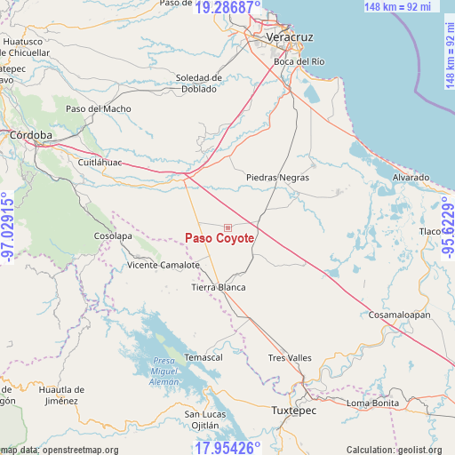
Paso Coyote GPS coordinates[2]
18° 37' 18.732" North, 96° 19' 33.672" West
| Map corner | latitude | longitude |
|---|---|---|
| Upper-left | 19.28687°, | -97.02915° |
| Center: | 18.62187°, | -96.32602° |
| Lower-right: | 17.95426°, | -95.6229° |
| Map W x H: | 148.2×148.2 km | = 92.1×92.1mi |
| max Lat: | 32.7° ⇑71.2% North |
| Paso Coyote: | 18.62187° |
| min Lat: | ⇓28.8% South 14.53588° |
| min Long | Paso Coyote | max Long |
| -117.105° | -96.32602° | -86.73105° |
| W 80.7%⇐ | ⇒19.3% E |
Elevation
Elevation of Paso Coyote is 70 m = 230 ft, and this is 1183.7 m = 3884 ft below average elevation for this country.
| Max E: |
3497 m = 11473 ft | 82% |
| Avg. | 1253.7 m = 4113 ft | |
| Paso Coyote | 70 m = 230 ft | |
Min E: |
-1 m = -3 ft | 18% |
See also: Mexico elevation on elevation.city.
Geographical zone
Paso Coyote is located in North Torrid zone (between Equator and Tropic of Cancer). Distance of this Northern Tropic circle is 535.4 km =332.7 mi to North.| Distance of | km | miles | from Paso Coyote |
|---|---|---|---|
| North Pole | 7936.5 | 4931.5 | to North |
| Arctic Circle | 5330.6 | 3312.3 | to North |
| Tropic Cancer | 535.4 | 332.7 | to North |
| Equator | 2070.6 | 1286.6 | to South |


Nearby cities:
15 places around Paso Coyote: (largest is in red/bold)
• Cuyucuenda
18.6 km =11.6 mi,  17°
17°
• El Amate
10.8 km =6.7 mi,  213°
213°
• El Contento
13.5 km =8.4 mi,  86°
86°
• El Jícaro
11.7 km =7.3 mi,  137°
137°
• El Quechuleño
13.9 km =8.6 mi,  244°
244°
• Huixcolotla
18.7 km =11.6 mi,  285°
285°
• Joachín
10 km =6.2 mi,  79°
79°
• La Campana
18.7 km =11.6 mi,  314°
314°
• La Isla
18.7 km =11.6 mi,  97°
97°
• La Victoria
18.2 km =11.3 mi,  179°
179°
• Los Mangos
4.5 km =2.8 mi,  283°
283°
• Mata de Lázaro
18.8 km =11.7 mi,  31°
31°
• Rodríguez Tejeda
9.5 km =5.9 mi, 276°
• Salvador Gonzalo García
9.7 km =6 mi, 275°
• Serenilla de Abajo
9.2 km =5.7 mi,  230°
230°
Sources, notices
• [Note1] Compared only with cities in Mexico existing in our database
• [Src1] Map data: © OpenStreetMap contributors (CC-BY-SA)
• [Src2] Other city data from geonames.org with taken over terms of usage.
• [Src3] Geographical zone / Annual Mean Temperature by Robert A. Rohde @ Wikipedia
