Serenilla de Abajo geodata
Serenilla de Abajo (Veracruz) is a populated place; located in Mexico in America/Mexico_City (GMT-6) time zone. With population of 535 people, there are 15842 cities with bigger population in this country. Compared to other cities in Mexico, 71.8% of cities are located further ↑North; 80.3% of cities are located further ←West and 80.5% of cities have higher elevation than Serenilla de Abajo. Note1


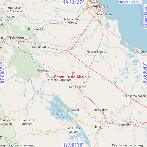
Serenilla de Abajo GPS coordinates[2]
18° 34' 9.012" North, 96° 23' 36.996" West
| Map corner | latitude | longitude |
|---|---|---|
| Upper-left | 19.23437°, | -97.09674° |
| Center: | 18.56917°, | -96.39361° |
| Lower-right: | 17.90136°, | -95.69049° |
| Map W x H: | 148.2×148.2 km | = 92.1×92.1mi |
| max Lat: | 32.7° ⇑71.8% North |
| Serenilla de Abajo: | 18.56917° |
| min Lat: | ⇓28.2% South 14.53588° |
| min Long | Serenilla de Ab | max Long |
| -117.105° | -96.39361° | -86.73105° |
| W 80.3%⇐ | ⇒19.7% E |
Elevation
Elevation of Serenilla de Abajo is 88 m = 289 ft, and this is 1165.7 m = 3824 ft below average elevation for this country.
| Max E: |
3497 m = 11473 ft | 80.5% |
| Avg. | 1253.7 m = 4113 ft | |
| Serenilla de Abajo | 88 m = 289 ft | |
Min E: |
-1 m = -3 ft | 19.5% |
See also: Mexico elevation on elevation.city.
Geographical zone
Serenilla de Abajo is located in North Torrid zone (between Equator and Tropic of Cancer). Distance of this Northern Tropic circle is 541.2 km =336.3 mi to North.| Distance of | km | miles | from Serenilla de Abajo |
|---|---|---|---|
| North Pole | 7942.4 | 4935.2 | to North |
| Arctic Circle | 5336.5 | 3315.9 | to North |
| Tropic Cancer | 541.2 | 336.3 | to North |
| Equator | 2064.7 | 1282.9 | to South |


Nearby cities:
15 places around Serenilla de Abajo: (largest is in red/bold)
• Carbonera
14.2 km =8.8 mi,  194°
194°
• Cañamazal
10.7 km =6.6 mi,  267°
267°
• El Amate
3.3 km =2.1 mi,  159°
159°
• El Jícaro
15.3 km =9.5 mi,  100°
100°
• El Porvenir
11.2 km =7 mi,  232°
232°
• El Quechuleño
5.5 km =3.4 mi, 269°
• Huixcolotla
15.3 km =9.5 mi,  314°
314°
• La Palma
12 km =7.5 mi,  200°
200°
• La Victoria
14.4 km =8.9 mi,  149°
149°
• Los Mangos
7.4 km =4.6 mi,  21°
21°
• Paso Coyote
9.2 km =5.7 mi,  50°
50°
• Rodríguez Tejeda
7.3 km =4.5 mi,  341°
341°
• Salvador Gonzalo García
7.3 km =4.5 mi, 339°
• Tetela
9.6 km =6 mi, 225°
• Tierra Blanca
14 km =8.7 mi, 164°
Sources, notices
• [Note1] Compared only with cities in Mexico existing in our database
• [Src1] Map data: © OpenStreetMap contributors (CC-BY-SA)
• [Src2] Other city data from geonames.org with taken over terms of usage.
• [Src3] Geographical zone / Annual Mean Temperature by Robert A. Rohde @ Wikipedia
