Jaumave geodata
Jaumave (Tamaulipas) is a seat of a second-order administrative division; located in Mexico in America/Monterrey (GMT-6) time zone. With population of 5,633 people, there are 1653 cities with bigger population in this country. Compared to other cities in Mexico, 88.8% of cities are located further ↓South; 55.4% of cities are located further →East and 64% of cities have higher elevation than Jaumave. Note1


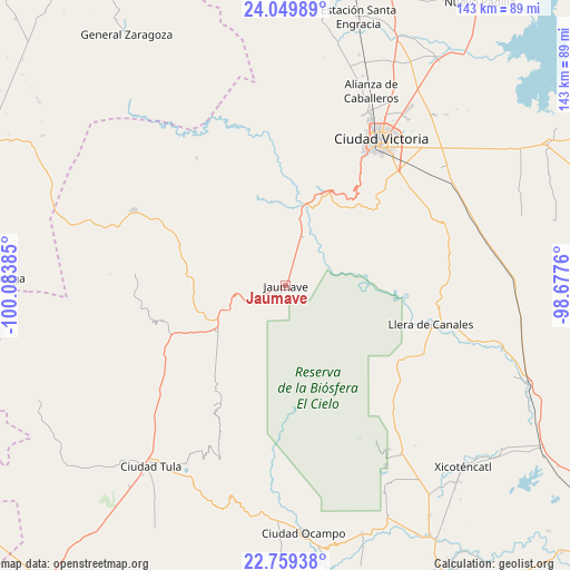
Jaumave GPS coordinates[2]
23° 24' 22.356" North, 99° 22' 50.592" West
| Map corner | latitude | longitude |
|---|---|---|
| Upper-left | 24.04989°, | -100.08385° |
| Center: | 23.40621°, | -99.38072° |
| Lower-right: | 22.75938°, | -98.6776° |
| Map W x H: | 143.5×143.5 km | = 89.2×89.2mi |
| max Lat: | 32.7° ⇑11.2% North |
| Jaumave: | 23.40621° |
| min Lat: | ⇓88.8% South 14.53588° |
| min Long | Jaumave | max Long |
| -117.105° | -99.38072° | -86.73105° |
| W 44.6%⇐ | ⇒55.4% E |
Elevation
Elevation of Jaumave is 753 m = 2470 ft, and this is 500.7 m = 1643 ft below average elevation for this country.
| Max E: |
3497 m = 11473 ft | 64% |
| Avg. | 1253.7 m = 4113 ft | |
| Jaumave | 753 m = 2470 ft | |
Min E: |
-1 m = -3 ft | 36% |
See also: Mexico elevation on elevation.city.
Geographical zone
Jaumave is located in North Torrid zone (between Equator and Tropic of Cancer). Distance of this Northern Tropic circle is 3.4 km =2.1 mi to North.| Distance of | km | miles | from Jaumave |
|---|---|---|---|
| North Pole | 7404.5 | 4600.9 | to North |
| Arctic Circle | 4798.6 | 2981.7 | to North |
| Tropic Cancer | 3.4 | 2.1 | to North |
| Equator | 2602.5 | 1617.1 | to South |


Nearby cities:
15 places around Jaumave: (largest is in red/bold)
• Bustamante
38.7 km =24 mi,  274°
274°
• Calabacillas
41.7 km =25.9 mi,  240°
240°
• Ciudad Victoria
44.3 km =27.5 mi,  32°
32°
• El Aguacate
40 km =24.9 mi,  257°
257°
• El Nuevo Encino (El Encino)
40.3 km =25 mi,  137°
137°
• El Olmo (Rancho Nuevo del Castillo)
44.3 km =27.5 mi,  42°
42°
• Felipe Ángeles
38.3 km =23.8 mi, 267°
• Francisco Medrano
19.3 km =12 mi,  5°
5°
• Juamave
0.1 km =0.1 mi,  149°
149°
• La Peña
35.6 km =22.1 mi,  298°
298°
• Llera de Canales
37.5 km =23.3 mi,  105°
105°
• Miquihuana
42.5 km =26.4 mi, 296°
• Palmillas
20.7 km =12.9 mi, 236°
• San Juanito
6.4 km =4 mi,  327°
327°
• Álvaro Obregón
41.1 km =25.5 mi,  231°
231°
Sources, notices
• [Note1] Compared only with cities in Mexico existing in our database
• [Src1] Map data: © OpenStreetMap contributors (CC-BY-SA)
• [Src2] Other city data from geonames.org with taken over terms of usage.
• [Src3] Geographical zone / Annual Mean Temperature by Robert A. Rohde @ Wikipedia
