La Peña geodata
La Peña (Tamaulipas) is a populated place; located in Mexico in America/Monterrey (GMT-6) time zone. With population of 699 people, there are 12460 cities with bigger population in this country. Compared to other cities in Mexico, 89% of cities are located further ↓South; 60.1% of cities are located further →East and 64.7% of cities have lower elevation than La Peña. Note1


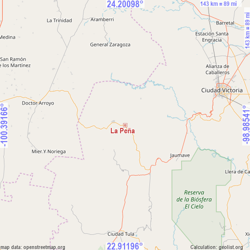
La Peña GPS coordinates[2]
23° 33' 28.98" North, 99° 41' 18.708" West
| Map corner | latitude | longitude |
|---|---|---|
| Upper-left | 24.20098°, | -100.39166° |
| Center: | 23.55805°, | -99.68853° |
| Lower-right: | 22.91196°, | -98.98541° |
| Map W x H: | 143.3×143.3 km | = 89×89mi |
| max Lat: | 32.7° ⇑11% North |
| La Peña: | 23.55805° |
| min Lat: | ⇓89% South 14.53588° |
| min Long | La Peña | max Long |
| -117.105° | -99.68853° | -86.73105° |
| W 39.9%⇐ | ⇒60.1% E |
Elevation
Elevation of La Peña is 1822 m = 5978 ft, and this is 568.3 m = 1865 ft above average elevation for this country.
| Max E: |
3497 m = 11473 ft | 35.3% |
| La Peña | 1822 m 5978 ft | |
| Avg. | 1253.7 m = 4113 ft | |
Min E: |
-1 m = -3 ft | 64.7% |
See also: Mexico elevation on elevation.city.
Geographical zone
La Peña is located in North temperate zone (between Tropic of Cancer and the Arctic Circle). Distance of this Northern Tropic circle is 13.5 km =8.4 mi to South.| Distance of | km | miles | from La Peña |
|---|---|---|---|
| North Pole | 7387.7 | 4590.5 | to North |
| Arctic Circle | 4781.8 | 2971.3 | to North |
| Tropic Cancer | 13.5 | 8.4 | to South |
| Equator | 2619.4 | 1627.6 | to South |


Nearby cities:
15 places around La Peña: (largest is in red/bold)
• Bustamante
15.4 km =9.6 mi,  207°
207°
• Calabacillas
38 km =23.6 mi,  187°
187°
• El Aguacate
26.4 km =16.4 mi,  197°
197°
• Felipe Ángeles
20 km =12.4 mi, 199°
• Francisco Medrano
33.2 km =20.6 mi,  85°
85°
• Jaumave
35.6 km =22.1 mi,  118°
118°
• Juamave
35.7 km =22.2 mi, 118°
• La Cardona
34.4 km =21.4 mi,  239°
239°
• Mier y Noriega
46.2 km =28.7 mi,  250°
250°
• Miquihuana
7 km =4.3 mi,  286°
286°
• Palmillas
31.8 km =19.8 mi,  153°
153°
• Salitrillo
46.1 km =28.6 mi, 197°
• San José del Llano
25.3 km =15.7 mi,  264°
264°
• San Juanito
30.2 km =18.8 mi,  112°
112°
• Álvaro Obregón
42.7 km =26.5 mi,  180°
180°
Sources, notices
• [Note1] Compared only with cities in Mexico existing in our database
• [Src1] Map data: © OpenStreetMap contributors (CC-BY-SA)
• [Src2] Other city data from geonames.org with taken over terms of usage.
• [Src3] Geographical zone / Annual Mean Temperature by Robert A. Rohde @ Wikipedia
