Miquihuana geodata
Miquihuana (Tamaulipas) is a seat of a second-order administrative division; located in Mexico in America/Monterrey (GMT-6) time zone. With population of 1,565 people, there are 5519 cities with bigger population in this country. Compared to other cities in Mexico, 89.1% of cities are located further ↓South; 60.8% of cities are located further →East and 66.7% of cities have lower elevation than Miquihuana. Note1


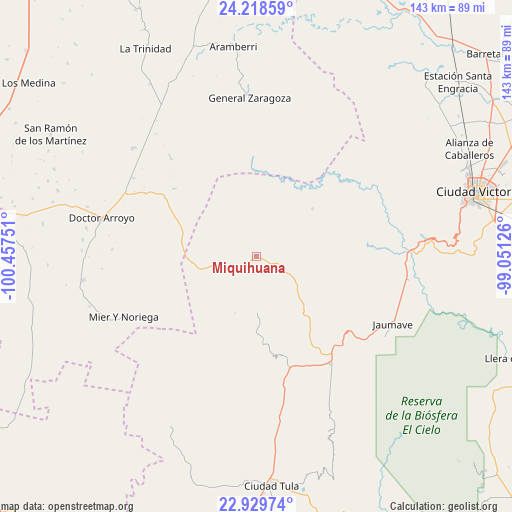
Miquihuana GPS coordinates[2]
23° 34' 32.7" North, 99° 45' 15.768" West
| Map corner | latitude | longitude |
|---|---|---|
| Upper-left | 24.21859°, | -100.45751° |
| Center: | 23.57575°, | -99.75438° |
| Lower-right: | 22.92974°, | -99.05126° |
| Map W x H: | 143.3×143.3 km | = 89×89mi |
| max Lat: | 32.7° ⇑10.9% North |
| Miquihuana: | 23.57575° |
| min Lat: | ⇓89.1% South 14.53588° |
| min Long | Miquihuana | max Long |
| -117.105° | -99.75438° | -86.73105° |
| W 39.2%⇐ | ⇒60.8% E |
Elevation
Elevation of Miquihuana is 1863 m = 6112 ft, and this is 609.3 m = 1999 ft above average elevation for this country.
| Max E: |
3497 m = 11473 ft | 33.3% |
| Miquihuana | 1863 m 6112 ft | |
| Avg. | 1253.7 m = 4113 ft | |
Min E: |
-1 m = -3 ft | 66.7% |
See also: Mexico elevation on elevation.city.
Geographical zone
Miquihuana is located in North temperate zone (between Tropic of Cancer and the Arctic Circle). Distance of this Northern Tropic circle is 15.5 km =9.6 mi to South.| Distance of | km | miles | from Miquihuana |
|---|---|---|---|
| North Pole | 7385.7 | 4589.3 | to North |
| Arctic Circle | 4779.8 | 2970 | to North |
| Tropic Cancer | 15.5 | 9.6 | to South |
| Equator | 2621.4 | 1628.9 | to South |


Nearby cities:
15 places around Miquihuana: (largest is in red/bold)
• Bustamante
15.6 km =9.7 mi,  181°
181°
• Calabacillas
39.7 km =24.7 mi, 177°
• El Aguacate
27.2 km =16.9 mi, 182°
• Felipe Ángeles
20.8 km =12.9 mi, 180°
• Francisco Medrano
39.8 km =24.7 mi,  89°
89°
• General Zaragoza
44.2 km =27.5 mi,  357°
357°
• Jaumave
42.5 km =26.4 mi,  116°
116°
• Juamave
42.6 km =26.5 mi, 116°
• La Cardona
30 km =18.6 mi,  230°
230°
• La Peña
7 km =4.3 mi,  106°
106°
• Las Palomas (Lajillas)
43.6 km =27.1 mi,  265°
265°
• Mier y Noriega
40.7 km =25.3 mi,  245°
245°
• Palmillas
36.9 km =22.9 mi,  145°
145°
• San José del Llano
19 km =11.8 mi,  256°
256°
• San Juanito
37.2 km =23.1 mi, 111°
Sources, notices
• [Note1] Compared only with cities in Mexico existing in our database
• [Src1] Map data: © OpenStreetMap contributors (CC-BY-SA)
• [Src2] Other city data from geonames.org with taken over terms of usage.
• [Src3] Geographical zone / Annual Mean Temperature by Robert A. Rohde @ Wikipedia
