Iztapalapa geodata
Iztapalapa (Mexico City) is a populated place; located in Mexico in America/Mexico_City (GMT-6) time zone. With population of 1,815,786 people, there is 1 city with bigger population in this country. Compared to other cities in Mexico, 57.4% of cities are located further ↑North; 50.6% of cities are located further →East and 83.8% of cities have lower elevation than Iztapalapa. Note1


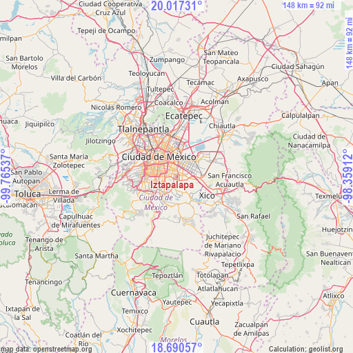
Iztapalapa GPS coordinates[2]
19° 21' 19.044" North, 99° 3' 44.064" West
| Map corner | latitude | longitude |
|---|---|---|
| Upper-left | 20.01731°, | -99.76537° |
| Center: | 19.35529°, | -99.06224° |
| Lower-right: | 18.69057°, | -98.35912° |
| Map W x H: | 147.5×147.5 km | = 91.7×91.7mi |
| max Lat: | 32.7° ⇑57.4% North |
| Iztapalapa: | 19.35529° |
| min Lat: | ⇓42.6% South 14.53588° |
| min Long | Iztapalapa | max Long |
| -117.105° | -99.06224° | -86.73105° |
| W 49.4%⇐ | ⇒50.6% E |
Elevation
Elevation of Iztapalapa is 2238 m = 7343 ft, and this is 984.3 m = 3229 ft above average elevation for this country.
| Max E: |
3497 m = 11473 ft | 16.2% |
| Iztapalapa | 2238 m 7343 ft | |
| Avg. | 1253.7 m = 4113 ft | |
Min E: |
-1 m = -3 ft | 83.8% |
See also: Iztapalapa elevation on elevation.city.
Geographical zone
Iztapalapa is located in North Torrid zone (between Equator and Tropic of Cancer). Distance of this Northern Tropic circle is 453.8 km =282 mi to North.| Distance of | km | miles | from Iztapalapa |
|---|---|---|---|
| North Pole | 7855 | 4880.9 | to North |
| Arctic Circle | 5249.1 | 3261.6 | to North |
| Tropic Cancer | 453.8 | 282 | to North |
| Equator | 2152.1 | 1337.3 | to South |


Nearby cities:
15 places around Iztapalapa: (largest is in red/bold)
• Benito Juárez
10.1 km =6.3 mi,  281°
281°
• Ciudad Nezahualcoyotl
7.1 km =4.4 mi,  44°
44°
• Colonia Gustavo Baz Prada
8.9 km =5.5 mi,  34°
34°
• Colonia Nativitas
8.3 km =5.2 mi,  290°
290°
• Coyoacán
10.5 km =6.5 mi,  264°
264°
• El Paraíso (Mecoxtla)
9.7 km =6 mi,  110°
110°
• Emiliano Zapata
9.3 km =5.8 mi,  98°
98°
• Iztacalco
5.8 km =3.6 mi,  320°
320°
• Los Reyes Acaquilpan
9 km =5.6 mi,  84°
84°
• Mexico City
10.6 km =6.6 mi, 319°
• Nezahualcóyotl
8.1 km =5 mi,  63°
63°
• Polígonos
10.1 km =6.3 mi,  47°
47°
• Tecamachalco
10.8 km =6.7 mi,  87°
87°
• Tláhuac
9.7 km =6 mi,  141°
141°
• Venustiano Carranza
10.8 km =6.7 mi,  335°
335°
In other languages:
- In Spanish: Delegación Iztapalapa
- In Italian: Delegazione Iztapalapa
- In Russian: Истапалапа
- In Chinese: 伊斯塔帕拉帕
Sources, notices
• [Note1] Compared only with cities in Mexico existing in our database
• [Src1] Map data: © OpenStreetMap contributors (CC-BY-SA)
• [Src2] Other city data from geonames.org with taken over terms of usage.
• [Src3] Geographical zone / Annual Mean Temperature by Robert A. Rohde @ Wikipedia
