Benito Juárez geodata
Benito Juárez (Mexico City) is a section of populated place; located in Mexico in America/Mexico_City (GMT-6) time zone. With population of 385,439 people, there are 49 cities with bigger population in this country. Compared to other cities in Mexico, 57% of cities are located further ↑North; 52% of cities are located further →East and 84.9% of cities have lower elevation than Benito Juárez. Note1


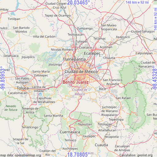
Benito Juárez GPS coordinates[2]
19° 22' 21.72" North, 99° 9' 23.04" West
| Map corner | latitude | longitude |
|---|---|---|
| Upper-left | 20.03465°, | -99.85953° |
| Center: | 19.3727°, | -99.1564° |
| Lower-right: | 18.70805°, | -98.45328° |
| Map W x H: | 147.5×147.5 km | = 91.7×91.7mi |
| max Lat: | 32.7° ⇑57% North |
| Benito Juárez: | 19.3727° |
| min Lat: | ⇓43% South 14.53588° |
| min Long | Benito Juárez | max Long |
| -117.105° | -99.1564° | -86.73105° |
| W 48%⇐ | ⇒52% E |
Elevation
Elevation of Benito Juárez is 2258 m = 7408 ft, and this is 1004.3 m = 3295 ft above average elevation for this country.
| Max E: |
3497 m = 11473 ft | 15.1% |
| Benito Juárez | 2258 m 7408 ft | |
| Avg. | 1253.7 m = 4113 ft | |
Min E: |
-1 m = -3 ft | 84.9% |
See also: Benito Juárez elevation on elevation.city.
Geographical zone
Benito Juárez is located in North Torrid zone (between Equator and Tropic of Cancer). Distance of this Northern Tropic circle is 451.9 km =280.8 mi to North.| Distance of | km | miles | from Benito Juárez |
|---|---|---|---|
| North Pole | 7853 | 4879.6 | to North |
| Arctic Circle | 5247.1 | 3260.4 | to North |
| Tropic Cancer | 451.9 | 280.8 | to North |
| Equator | 2154 | 1338.4 | to South |


Nearby cities:
15 places around Benito Juárez: (largest is in red/bold)
• Benito Juarez
2.9 km =1.8 mi,  357°
357°
• Col. Bosques de las Lomas
11.5 km =7.1 mi,  273°
273°
• Colonia Nativitas
2.3 km =1.4 mi,  65°
65°
• Colonia del Valle
1.6 km =1 mi,  338°
338°
• Coyoacán
2.9 km =1.8 mi,  190°
190°
• Cuauhtémoc
8.1 km =5 mi,  7°
7°
• Iztacalco
6.6 km =4.1 mi, 67°
• Iztapalapa
10.1 km =6.3 mi,  101°
101°
• Magdalena Contreras
7.3 km =4.5 mi,  231°
231°
• Mexico City
6.9 km =4.3 mi,  25°
25°
• Miguel Hidalgo
8.2 km =5.1 mi,  326°
326°
• Polanco
8.1 km =5 mi, 326°
• Tlalpan
8.6 km =5.3 mi,  183°
183°
• Venustiano Carranza
9.6 km =6 mi, 34°
• Álvaro Obregón
5.2 km =3.2 mi,  252°
252°
Sources, notices
• [Note1] Compared only with cities in Mexico existing in our database
• [Src1] Map data: © OpenStreetMap contributors (CC-BY-SA)
• [Src2] Other city data from geonames.org with taken over terms of usage.
• [Src3] Geographical zone / Annual Mean Temperature by Robert A. Rohde @ Wikipedia
