Iztacalco geodata
Iztacalco (Mexico City) is a populated place; located in Mexico in America/Mexico_City (GMT-6) time zone. With population of 384,326 people, there are 50 cities with bigger population in this country. Compared to other cities in Mexico, 56.4% of cities are located further ↑North; 51.1% of cities are located further →East and 83.8% of cities have lower elevation than Iztacalco. Note1


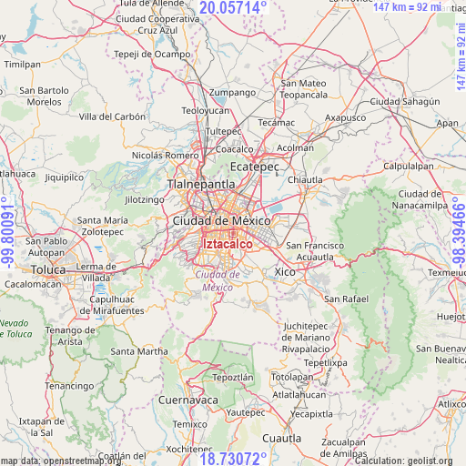
Iztacalco GPS coordinates[2]
19° 23' 43.008" North, 99° 5' 52.008" West
| Map corner | latitude | longitude |
|---|---|---|
| Upper-left | 20.05714°, | -99.80091° |
| Center: | 19.39528°, | -99.09778° |
| Lower-right: | 18.73072°, | -98.39466° |
| Map W x H: | 147.5×147.5 km | = 91.7×91.7mi |
| max Lat: | 32.7° ⇑56.4% North |
| Iztacalco: | 19.39528° |
| min Lat: | ⇓43.6% South 14.53588° |
| min Long | Iztacalco | max Long |
| -117.105° | -99.09778° | -86.73105° |
| W 48.9%⇐ | ⇒51.1% E |
Elevation
Elevation of Iztacalco is 2239 m = 7346 ft, and this is 985.3 m = 3233 ft above average elevation for this country.
| Max E: |
3497 m = 11473 ft | 16.2% |
| Iztacalco | 2239 m 7346 ft | |
| Avg. | 1253.7 m = 4113 ft | |
Min E: |
-1 m = -3 ft | 83.8% |
See also: Iztacalco elevation on elevation.city.
Geographical zone
Iztacalco is located in North Torrid zone (between Equator and Tropic of Cancer). Distance of this Northern Tropic circle is 449.4 km =279.2 mi to North.| Distance of | km | miles | from Iztacalco |
|---|---|---|---|
| North Pole | 7850.5 | 4878.1 | to North |
| Arctic Circle | 5244.6 | 3258.8 | to North |
| Tropic Cancer | 449.4 | 279.2 | to North |
| Equator | 2156.6 | 1340 | to South |


Nearby cities:
15 places around Iztacalco: (largest is in red/bold)
• Benito Juarez
6.3 km =3.9 mi,  273°
273°
• Benito Juárez
6.6 km =4.1 mi,  247°
247°
• Ciudad Nezahualcoyotl
8.7 km =5.4 mi,  86°
86°
• Colonia Gustavo Baz Prada
9.3 km =5.8 mi,  71°
71°
• Colonia Lindavista
11.1 km =6.9 mi,  345°
345°
• Colonia Nativitas
4.4 km =2.7 mi, 249°
• Colonia del Valle
6.8 km =4.2 mi,  261°
261°
• Coyoacán
8.6 km =5.3 mi,  231°
231°
• Cuauhtémoc
7.5 km =4.7 mi,  317°
317°
• Gustavo Adolfo Madero
11.1 km =6.9 mi, 352°
• Iztapalapa
5.8 km =3.6 mi,  140°
140°
• Mexico City
4.8 km =3 mi, 319°
• Nezahualcóyotl
11.1 km =6.9 mi, 94°
• Polígonos
11.4 km =7.1 mi,  78°
78°
• Venustiano Carranza
5.4 km =3.4 mi, 351°
Sources, notices
• [Note1] Compared only with cities in Mexico existing in our database
• [Src1] Map data: © OpenStreetMap contributors (CC-BY-SA)
• [Src2] Other city data from geonames.org with taken over terms of usage.
• [Src3] Geographical zone / Annual Mean Temperature by Robert A. Rohde @ Wikipedia
