San José geodata
San José (Hidalgo) is a populated place; located in Mexico in America/Mexico_City (GMT-6) time zone. With population of 1,126 people, there are 7698 cities with bigger population in this country. Compared to other cities in Mexico, 77.4% of cities are located further ↓South; 56.2% of cities are located further ←West and 69.7% of cities have higher elevation than San José. Note1


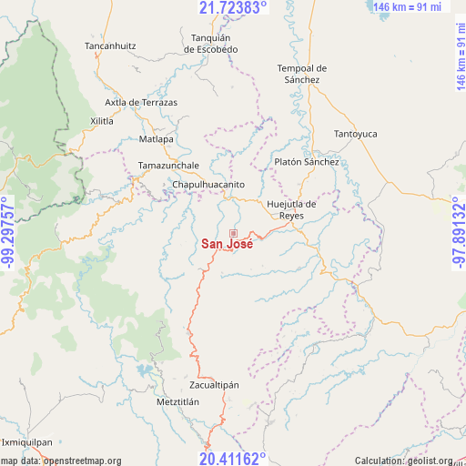
San José GPS coordinates[2]
21° 4' 9.012" North, 98° 35' 39.984" West
| Map corner | latitude | longitude |
|---|---|---|
| Upper-left | 21.72383°, | -99.29757° |
| Center: | 21.06917°, | -98.59444° |
| Lower-right: | 20.41162°, | -97.89132° |
| Map W x H: | 145.9×145.9 km | = 90.7×90.7mi |
| max Lat: | 32.7° ⇑22.6% North |
| San José: | 21.06917° |
| min Lat: | ⇓77.4% South 14.53588° |
| min Long | San José | max Long |
| -117.105° | -98.59444° | -86.73105° |
| W 56.2%⇐ | ⇒43.8% E |
Elevation
Elevation of San José is 431 m = 1414 ft, and this is 822.7 m = 2699 ft below average elevation for this country.
| Max E: |
3497 m = 11473 ft | 69.7% |
| Avg. | 1253.7 m = 4113 ft | |
| San José | 431 m = 1414 ft | |
Min E: |
-1 m = -3 ft | 30.3% |
See also: Mexico elevation on elevation.city.
Geographical zone
San José is located in North Torrid zone (between Equator and Tropic of Cancer). Distance of this Northern Tropic circle is 263.2 km =163.5 mi to North.| Distance of | km | miles | from San José |
|---|---|---|---|
| North Pole | 7664.4 | 4762.4 | to North |
| Arctic Circle | 5058.5 | 3143.2 | to North |
| Tropic Cancer | 263.2 | 163.5 | to North |
| Equator | 2342.7 | 1455.7 | to South |


Nearby cities:
15 places around San José: (largest is in red/bold)
• Acatipa
2.6 km =1.6 mi,  140°
140°
• Apantlazol
8.9 km =5.5 mi,  172°
172°
• Axcaco
5.6 km =3.5 mi,  88°
88°
• Chatipán
8.9 km =5.5 mi,  128°
128°
• Coacuilco
3.9 km =2.4 mi,  12°
12°
• Cuapaxtitla
8.3 km =5.2 mi,  31°
31°
• Cuatlimax
7.7 km =4.8 mi,  293°
293°
• Hueyapa
9.9 km =6.2 mi,  280°
280°
• Ixcatlán
6.3 km =3.9 mi,  77°
77°
• Ixcatépec
8.6 km =5.3 mi,  65°
65°
• Jaltocan
9.1 km =5.7 mi,  39°
39°
• Peyula
4 km =2.5 mi,  145°
145°
• Talol
6.6 km =4.1 mi,  329°
329°
• Tehuetlán
9.1 km =5.7 mi,  101°
101°
• Toctitlán
6.6 km =4.1 mi, 168°
Sources, notices
• [Note1] Compared only with cities in Mexico existing in our database
• [Src1] Map data: © OpenStreetMap contributors (CC-BY-SA)
• [Src2] Other city data from geonames.org with taken over terms of usage.
• [Src3] Geographical zone / Annual Mean Temperature by Robert A. Rohde @ Wikipedia
