Ignacio Allende geodata
Ignacio Allende (Tabasco) is a populated place; located in Mexico in America/Mexico_City (GMT-6) time zone. With population of 695 people, there are 12521 cities with bigger population in this country. Compared to other cities in Mexico, 85.2% of cities are located further ↑North; 96.6% of cities are located further ←West and 77.1% of cities have higher elevation than Ignacio Allende. Note1


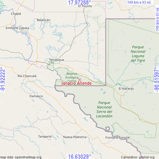
Ignacio Allende GPS coordinates[2]
17° 18' 10.116" North, 91° 13' 8.724" West
| Map corner | latitude | longitude |
|---|---|---|
| Upper-left | 17.97288°, | -91.92222° |
| Center: | 17.30281°, | -91.21909° |
| Lower-right: | 16.63029°, | -90.51597° |
| Map W x H: | 149.3×149.3 km | = 92.8×92.8mi |
| max Lat: | 32.7° ⇑85.2% North |
| Ignacio Allende: | 17.30281° |
| min Lat: | ⇓14.8% South 14.53588° |
| min Long | Ignacio Allende | max Long |
| -117.105° | -91.21909° | -86.73105° |
| W 96.6%⇐ | ⇒3.4% E |
Elevation
Elevation of Ignacio Allende is 152 m = 499 ft, and this is 1101.7 m = 3615 ft below average elevation for this country.
| Max E: |
3497 m = 11473 ft | 77.1% |
| Avg. | 1253.7 m = 4113 ft | |
| Ignacio Allende | 152 m = 499 ft | |
Min E: |
-1 m = -3 ft | 22.9% |
See also: Mexico elevation on elevation.city.
Geographical zone
Ignacio Allende is located in North Torrid zone (between Equator and Tropic of Cancer). Distance of this Northern Tropic circle is 682 km =423.8 mi to North.| Distance of | km | miles | from Ignacio Allende |
|---|---|---|---|
| North Pole | 8083.2 | 5022.7 | to North |
| Arctic Circle | 5477.3 | 3403.4 | to North |
| Tropic Cancer | 682 | 423.8 | to North |
| Equator | 1923.9 | 1195.5 | to South |


Nearby cities:
15 places around Ignacio Allende: (largest is in red/bold)
• Arroyo Jerusalén
22.8 km =14.2 mi,  191°
191°
• Busiljá
31 km =19.3 mi,  209°
209°
• Certeza
23.7 km =14.7 mi,  317°
317°
• El Chamizal
27.7 km =17.2 mi,  38°
38°
• El Palmar
25.2 km =15.7 mi,  49°
49°
• Jolochero
28.9 km =18 mi,  31°
31°
• Mactún
32.9 km =20.4 mi,  346°
346°
• Nueva Libertad
24.4 km =15.2 mi,  202°
202°
• Nuevo Francisco León
32.2 km =20 mi, 199°
• Paraíso (El Tinto)
32.6 km =20.3 mi,  14°
14°
• Redención del Campesino
7.5 km =4.7 mi,  291°
291°
• San Carlos
28.6 km =17.8 mi, 13°
• Santa Cruz
24.2 km =15 mi,  58°
58°
• Tenosique
28.8 km =17.9 mi,  311°
311°
• Álvaro Obregón
1.9 km =1.2 mi,  216°
216°
Sources, notices
• [Note1] Compared only with cities in Mexico existing in our database
• [Src1] Map data: © OpenStreetMap contributors (CC-BY-SA)
• [Src2] Other city data from geonames.org with taken over terms of usage.
• [Src3] Geographical zone / Annual Mean Temperature by Robert A. Rohde @ Wikipedia
