Certeza geodata
Certeza (Tabasco) is a populated place; located in Mexico in America/Mexico_City (GMT-6) time zone. With population of 675 people, there are 12870 cities with bigger population in this country. Compared to other cities in Mexico, 83.5% of cities are located further ↑North; 96.5% of cities are located further ←West and 84.8% of cities have higher elevation than Certeza. Note1


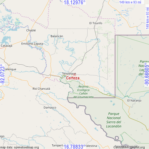
Certeza GPS coordinates[2]
17° 27' 37.008" North, 91° 22' 9.012" West
| Map corner | latitude | longitude |
|---|---|---|
| Upper-left | 18.12976°, | -92.0723° |
| Center: | 17.46028°, | -91.36917° |
| Lower-right: | 16.78833°, | -90.66605° |
| Map W x H: | 149.2×149.2 km | = 92.7×92.7mi |
| max Lat: | 32.7° ⇑83.5% North |
| Certeza: | 17.46028° |
| min Lat: | ⇓16.5% South 14.53588° |
| min Long | Certeza | max Long |
| -117.105° | -91.36917° | -86.73105° |
| W 96.5%⇐ | ⇒3.5% E |
Elevation
Elevation of Certeza is 45 m = 148 ft, and this is 1208.7 m = 3966 ft below average elevation for this country.
| Max E: |
3497 m = 11473 ft | 84.8% |
| Avg. | 1253.7 m = 4113 ft | |
| Certeza | 45 m = 148 ft | |
Min E: |
-1 m = -3 ft | 15.2% |
See also: Mexico elevation on elevation.city.
Geographical zone
Certeza is located in North Torrid zone (between Equator and Tropic of Cancer). Distance of this Northern Tropic circle is 664.5 km =412.9 mi to North.| Distance of | km | miles | from Certeza |
|---|---|---|---|
| North Pole | 8065.7 | 5011.8 | to North |
| Arctic Circle | 5459.8 | 3392.6 | to North |
| Tropic Cancer | 664.5 | 412.9 | to North |
| Equator | 1941.4 | 1206.3 | to South |


Nearby cities:
15 places around Certeza: (largest is in red/bold)
• Arena de Hidalgo
23.3 km =14.5 mi,  269°
269°
• El Águila
24.3 km =15.1 mi,  27°
27°
• Estapilla
10.1 km =6.3 mi,  337°
337°
• General Luis Felipe Domínguez Suárez
28.1 km =17.5 mi,  320°
320°
• Ignacio Allende
23.7 km =14.7 mi,  137°
137°
• La Isla
12.5 km =7.8 mi,  280°
280°
• Lázaro Cárdenas
22.3 km =13.9 mi,  240°
240°
• Mactún
16.5 km =10.3 mi, 29°
• Multé
25.4 km =15.8 mi,  357°
357°
• Paraíso (El Tinto)
27.8 km =17.3 mi,  59°
59°
• Redención del Campesino
17.2 km =10.7 mi,  148°
148°
• San Carlos
25 km =15.5 mi,  65°
65°
• Tenosique
5.9 km =3.7 mi, 283°
• Usumacinta
16.7 km =10.4 mi,  308°
308°
• Álvaro Obregón
24.1 km =15 mi, 142°
Sources, notices
• [Note1] Compared only with cities in Mexico existing in our database
• [Src1] Map data: © OpenStreetMap contributors (CC-BY-SA)
• [Src2] Other city data from geonames.org with taken over terms of usage.
• [Src3] Geographical zone / Annual Mean Temperature by Robert A. Rohde @ Wikipedia
