Santa Cruz Hidalgo geodata
Santa Cruz Hidalgo (Veracruz) is a populated place; located in Mexico in America/Mexico_City (GMT-6) time zone. With population of 821 people, there are 10634 cities with bigger population in this country. Compared to other cities in Mexico, 56.3% of cities are located further ↓South; 76.3% of cities are located further ←West and 79.1% of cities have higher elevation than Santa Cruz Hidalgo. Note1


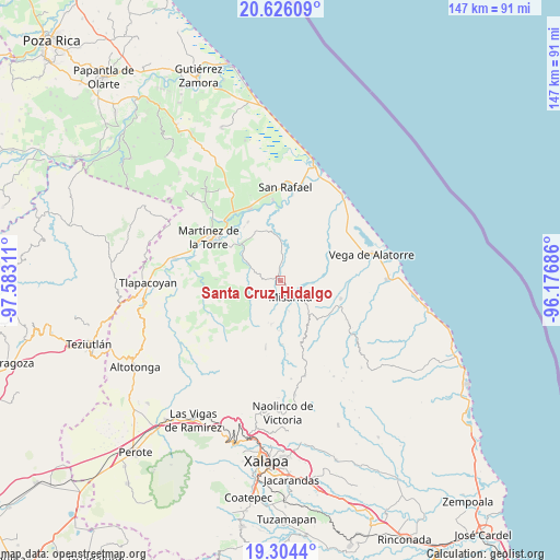
Santa Cruz Hidalgo GPS coordinates[2]
19° 57' 59.868" North, 96° 52' 47.928" West
| Map corner | latitude | longitude |
|---|---|---|
| Upper-left | 20.62609°, | -97.58311° |
| Center: | 19.96663°, | -96.87998° |
| Lower-right: | 19.3044°, | -96.17686° |
| Map W x H: | 147×147 km | = 91.3×91.3mi |
| max Lat: | 32.7° ⇑43.7% North |
| Santa Cruz Hidalgo: | 19.96663° |
| min Lat: | ⇓56.3% South 14.53588° |
| min Long | Santa Cruz Hida | max Long |
| -117.105° | -96.87998° | -86.73105° |
| W 76.3%⇐ | ⇒23.7% E |
Elevation
Elevation of Santa Cruz Hidalgo is 110 m = 361 ft, and this is 1143.7 m = 3752 ft below average elevation for this country.
| Max E: |
3497 m = 11473 ft | 79.1% |
| Avg. | 1253.7 m = 4113 ft | |
| Santa Cruz Hidalgo | 110 m = 361 ft | |
Min E: |
-1 m = -3 ft | 20.9% |
See also: Mexico elevation on elevation.city.
Geographical zone
Santa Cruz Hidalgo is located in North Torrid zone (between Equator and Tropic of Cancer). Distance of this Northern Tropic circle is 385.8 km =239.7 mi to North.| Distance of | km | miles | from Santa Cruz Hidalgo |
|---|---|---|---|
| North Pole | 7787 | 4838.6 | to North |
| Arctic Circle | 5181.1 | 3219.4 | to North |
| Tropic Cancer | 385.8 | 239.7 | to North |
| Equator | 2220.1 | 1379.5 | to South |


Nearby cities:
15 places around Santa Cruz Hidalgo: (largest is in red/bold)
• Arroyo Frío
12 km =7.5 mi,  91°
91°
• Arroyo Hondo
6.3 km =3.9 mi,  5°
5°
• Coapeche
13.4 km =8.3 mi,  349°
349°
• El Ciervo
12.9 km =8 mi,  58°
58°
• Francisco Sarabia
11.2 km =7 mi,  301°
301°
• Ignacio Zaragoza
7 km =4.3 mi,  286°
286°
• La Martinica
10 km =6.2 mi, 10°
• La Primavera
3.5 km =2.2 mi,  355°
355°
• La Reforma (Kilómetro 9)
11.5 km =7.1 mi,  140°
140°
• Loma del Cojolite
6.2 km =3.9 mi,  81°
81°
• Misantla
5 km =3.1 mi, 144°
• Paso Blanco
11 km =6.8 mi,  176°
176°
• Plan de la Vega
8.5 km =5.3 mi,  98°
98°
• Venustiano Carranza
10 km =6.2 mi,  133°
133°
• Vicente Guerrero
11.7 km =7.3 mi,  191°
191°
Sources, notices
• [Note1] Compared only with cities in Mexico existing in our database
• [Src1] Map data: © OpenStreetMap contributors (CC-BY-SA)
• [Src2] Other city data from geonames.org with taken over terms of usage.
• [Src3] Geographical zone / Annual Mean Temperature by Robert A. Rohde @ Wikipedia
