Loma del Cojolite geodata
Loma del Cojolite (Veracruz) is a populated place; located in Mexico in America/Mexico_City (GMT-6) time zone. With population of 633 people, there are 13682 cities with bigger population in this country. Compared to other cities in Mexico, 56.5% of cities are located further ↓South; 77% of cities are located further ←West and 70.1% of cities have higher elevation than Loma del Cojolite. Note1


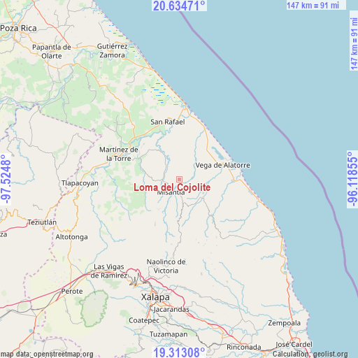
Loma del Cojolite GPS coordinates[2]
19° 58' 31.008" North, 96° 49' 18.012" West
| Map corner | latitude | longitude |
|---|---|---|
| Upper-left | 20.63471°, | -97.5248° |
| Center: | 19.97528°, | -96.82167° |
| Lower-right: | 19.31308°, | -96.11855° |
| Map W x H: | 147×147 km | = 91.3×91.3mi |
| max Lat: | 32.7° ⇑43.5% North |
| Loma del Cojolite: | 19.97528° |
| min Lat: | ⇓56.5% South 14.53588° |
| min Long | Loma del Cojoli | max Long |
| -117.105° | -96.82167° | -86.73105° |
| W 77%⇐ | ⇒23% E |
Elevation
Elevation of Loma del Cojolite is 412 m = 1352 ft, and this is 841.7 m = 2761 ft below average elevation for this country.
| Max E: |
3497 m = 11473 ft | 70.1% |
| Avg. | 1253.7 m = 4113 ft | |
| Loma del Cojolite | 412 m = 1352 ft | |
Min E: |
-1 m = -3 ft | 29.9% |
See also: Mexico elevation on elevation.city.
Geographical zone
Loma del Cojolite is located in North Torrid zone (between Equator and Tropic of Cancer). Distance of this Northern Tropic circle is 384.9 km =239.2 mi to North.| Distance of | km | miles | from Loma del Cojolite |
|---|---|---|---|
| North Pole | 7786 | 4838 | to North |
| Arctic Circle | 5180.1 | 3218.8 | to North |
| Tropic Cancer | 384.9 | 239.2 | to North |
| Equator | 2221 | 1380.1 | to South |


Nearby cities:
15 places around Loma del Cojolite: (largest is in red/bold)
• Arroyo Frío
6 km =3.7 mi,  101°
101°
• Arroyo Hondo
7.6 km =4.7 mi,  314°
314°
• Colipa
11.5 km =7.1 mi,  120°
120°
• El Ciervo
7.5 km =4.7 mi,  40°
40°
• Ignacio Zaragoza
12.9 km =8 mi,  274°
274°
• La Martinica
9.8 km =6.1 mi,  334°
334°
• La Primavera
6.9 km =4.3 mi,  291°
291°
• La Reforma (Kilómetro 9)
9.9 km =6.2 mi,  172°
172°
• Leona Vicario
13.6 km =8.5 mi, 170°
• Misantla
6 km =3.7 mi,  212°
212°
• Paso Blanco
13.1 km =8.1 mi,  204°
204°
• Plan de la Vega
3.2 km =2 mi,  133°
133°
• Santa Cruz Hidalgo
6.2 km =3.9 mi,  261°
261°
• Venustiano Carranza
7.9 km =4.9 mi, 170°
• Yecuatla
13 km =8.1 mi,  159°
159°
Sources, notices
• [Note1] Compared only with cities in Mexico existing in our database
• [Src1] Map data: © OpenStreetMap contributors (CC-BY-SA)
• [Src2] Other city data from geonames.org with taken over terms of usage.
• [Src3] Geographical zone / Annual Mean Temperature by Robert A. Rohde @ Wikipedia
