Coapeche geodata
Coapeche (Veracruz) is a populated place; located in Mexico in America/Mexico_City (GMT-6) time zone. With population of 674 people, there are 12893 cities with bigger population in this country. Compared to other cities in Mexico, 58.8% of cities are located further ↓South; 76.1% of cities are located further ←West and 87.5% of cities have higher elevation than Coapeche. Note1


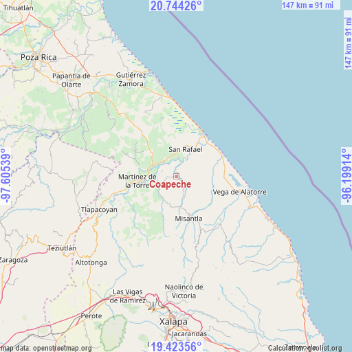
Coapeche GPS coordinates[2]
20° 5' 7.08" North, 96° 54' 8.136" West
| Map corner | latitude | longitude |
|---|---|---|
| Upper-left | 20.74426°, | -97.60539° |
| Center: | 20.0853°, | -96.90226° |
| Lower-right: | 19.42356°, | -96.19914° |
| Map W x H: | 146.8×146.9 km | = 91.2×91.3mi |
| max Lat: | 32.7° ⇑41.2% North |
| Coapeche: | 20.0853° |
| min Lat: | ⇓58.8% South 14.53588° |
| min Long | Coapeche | max Long |
| -117.105° | -96.90226° | -86.73105° |
| W 76.1%⇐ | ⇒23.9% E |
Elevation
Elevation of Coapeche is 32 m = 105 ft, and this is 1221.7 m = 4008 ft below average elevation for this country.
| Max E: |
3497 m = 11473 ft | 87.5% |
| Avg. | 1253.7 m = 4113 ft | |
| Coapeche | 32 m = 105 ft | |
Min E: |
-1 m = -3 ft | 12.5% |
See also: Mexico elevation on elevation.city.
Geographical zone
Coapeche is located in North Torrid zone (between Equator and Tropic of Cancer). Distance of this Northern Tropic circle is 372.6 km =231.5 mi to North.| Distance of | km | miles | from Coapeche |
|---|---|---|---|
| North Pole | 7773.8 | 4830.4 | to North |
| Arctic Circle | 5167.9 | 3211.2 | to North |
| Tropic Cancer | 372.6 | 231.5 | to North |
| Equator | 2233.3 | 1387.7 | to South |


Nearby cities:
15 places around Coapeche: (largest is in red/bold)
• Arroyo Hondo
7.5 km =4.7 mi,  156°
156°
• El Guayabal
10 km =6.2 mi,  16°
16°
• El Pital
8 km =5 mi,  3°
3°
• Felipe Carrillo Puerto
7.6 km =4.7 mi,  317°
317°
• Guadalupe Victoria
9.3 km =5.8 mi,  352°
352°
• Insurgentes
8.9 km =5.5 mi,  340°
340°
• La Defensa
6.5 km =4 mi,  289°
289°
• La Isla de Chapachapa
4.6 km =2.9 mi,  27°
27°
• La Libertad
8.2 km =5.1 mi,  244°
244°
• La Martinica
5.3 km =3.3 mi,  129°
129°
• La Primavera
9.9 km =6.2 mi,  168°
168°
• La Reforma
5.5 km =3.4 mi,  332°
332°
• Máximo García
7.1 km =4.4 mi,  278°
278°
• Palpoalanixcan
5.4 km =3.4 mi,  251°
251°
• Plan de Limón
9.6 km =6 mi, 247°
Sources, notices
• [Note1] Compared only with cities in Mexico existing in our database
• [Src1] Map data: © OpenStreetMap contributors (CC-BY-SA)
• [Src2] Other city data from geonames.org with taken over terms of usage.
• [Src3] Geographical zone / Annual Mean Temperature by Robert A. Rohde @ Wikipedia
