Fuentezuelas geodata
Fuentezuelas (Querétaro) is a populated place; located in Mexico in America/Mexico_City (GMT-6) time zone. With population of 2,895 people, there are 3074 cities with bigger population in this country. Compared to other cities in Mexico, 69% of cities are located further ↓South; 63.8% of cities are located further →East and 72.1% of cities have lower elevation than Fuentezuelas. Note1


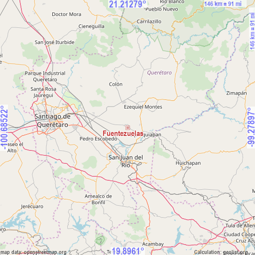
Fuentezuelas GPS coordinates[2]
20° 33' 21.096" North, 99° 58' 55.524" West
| Map corner | latitude | longitude |
|---|---|---|
| Upper-left | 21.21279°, | -100.68522° |
| Center: | 20.55586°, | -99.98209° |
| Lower-right: | 19.8961°, | -99.27897° |
| Map W x H: | 146.4×146.4 km | = 91×91mi |
| max Lat: | 32.7° ⇑31% North |
| Fuentezuelas: | 20.55586° |
| min Lat: | ⇓69% South 14.53588° |
| min Long | Fuentezuelas | max Long |
| -117.105° | -99.98209° | -86.73105° |
| W 36.2%⇐ | ⇒63.8% E |
Elevation
Elevation of Fuentezuelas is 1969 m = 6460 ft, and this is 715.3 m = 2347 ft above average elevation for this country.
| Max E: |
3497 m = 11473 ft | 27.9% |
| Fuentezuelas | 1969 m 6460 ft | |
| Avg. | 1253.7 m = 4113 ft | |
Min E: |
-1 m = -3 ft | 72.1% |
See also: Mexico elevation on elevation.city.
Geographical zone
Fuentezuelas is located in North Torrid zone (between Equator and Tropic of Cancer). Distance of this Northern Tropic circle is 320.3 km =199 mi to North.| Distance of | km | miles | from Fuentezuelas |
|---|---|---|---|
| North Pole | 7721.5 | 4797.9 | to North |
| Arctic Circle | 5115.6 | 3178.7 | to North |
| Tropic Cancer | 320.3 | 199 | to North |
| Equator | 2285.6 | 1420.2 | to South |


Nearby cities:
15 places around Fuentezuelas: (largest is in red/bold)
• Bordo Blanco
8.7 km =5.4 mi,  139°
139°
• El Tejocote
9 km =5.6 mi,  322°
322°
• La Fuente
5.6 km =3.5 mi,  266°
266°
• La Laja
2.1 km =1.3 mi,  3°
3°
• La Llave
10 km =6.2 mi,  186°
186°
• La Tortuga
6.3 km =3.9 mi,  78°
78°
• La Trinidad
4.9 km =3 mi,  155°
155°
• La Valla
7.8 km =4.8 mi,  216°
216°
• Laguna de Lourdes
11 km =6.8 mi, 219°
• Las Cenizas
11.1 km =6.9 mi,  300°
300°
• Los Cerritos
8.5 km =5.3 mi, 274°
• San José de la Laja
7 km =4.3 mi,  5°
5°
• San Nicolás
9.9 km =6.2 mi,  152°
152°
• Santillán
6.7 km =4.2 mi,  41°
41°
• Tequisquiapan
10.1 km =6.3 mi,  111°
111°
Sources, notices
• [Note1] Compared only with cities in Mexico existing in our database
• [Src1] Map data: © OpenStreetMap contributors (CC-BY-SA)
• [Src2] Other city data from geonames.org with taken over terms of usage.
• [Src3] Geographical zone / Annual Mean Temperature by Robert A. Rohde @ Wikipedia
