El Tejocote geodata
El Tejocote (Querétaro) is a populated place; located in Mexico in America/Mexico_City (GMT-6) time zone. With population of 2,701 people, there are 3278 cities with bigger population in this country. Compared to other cities in Mexico, 70.4% of cities are located further ↓South; 64.4% of cities are located further →East and 74.4% of cities have lower elevation than El Tejocote. Note1


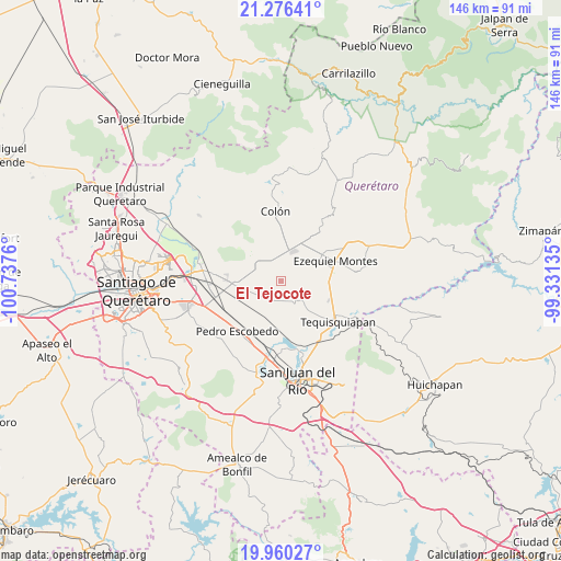
El Tejocote GPS coordinates[2]
20° 37' 11.136" North, 100° 2' 4.092" West
| Map corner | latitude | longitude |
|---|---|---|
| Upper-left | 21.27641°, | -100.7376° |
| Center: | 20.61976°, | -100.03447° |
| Lower-right: | 19.96027°, | -99.33135° |
| Map W x H: | 146.3×146.3 km | = 90.9×90.9mi |
| max Lat: | 32.7° ⇑29.6% North |
| El Tejocote: | 20.61976° |
| min Lat: | ⇓70.4% South 14.53588° |
| min Long | El Tejocote | max Long |
| -117.105° | -100.03447° | -86.73105° |
| W 35.6%⇐ | ⇒64.4% E |
Elevation
Elevation of El Tejocote is 2020 m = 6627 ft, and this is 766.3 m = 2514 ft above average elevation for this country.
| Max E: |
3497 m = 11473 ft | 25.6% |
| El Tejocote | 2020 m 6627 ft | |
| Avg. | 1253.7 m = 4113 ft | |
Min E: |
-1 m = -3 ft | 74.4% |
See also: Mexico elevation on elevation.city.
Geographical zone
El Tejocote is located in North Torrid zone (between Equator and Tropic of Cancer). Distance of this Northern Tropic circle is 313.2 km =194.6 mi to North.| Distance of | km | miles | from El Tejocote |
|---|---|---|---|
| North Pole | 7714.4 | 4793.5 | to North |
| Arctic Circle | 5108.5 | 3174.3 | to North |
| Tropic Cancer | 313.2 | 194.6 | to North |
| Equator | 2292.7 | 1424.6 | to South |


Nearby cities:
15 places around El Tejocote: (largest is in red/bold)
• Ajuchitlán
9.8 km =6.1 mi,  8°
8°
• El Blanco
7 km =4.3 mi,  262°
262°
• El Gallo
5.7 km =3.5 mi,  347°
347°
• Esperanza
8.5 km =5.3 mi,  290°
290°
• Fuentezuelas
9 km =5.6 mi,  142°
142°
• La Fuente
7.5 km =4.7 mi,  181°
181°
• La Laja
7.5 km =4.7 mi,  131°
131°
• Las Cenizas
4.3 km =2.7 mi,  249°
249°
• Los Cerritos
7.1 km =4.4 mi,  205°
205°
• México Lindo
8.6 km =5.3 mi,  238°
238°
• Purísima de Cubos (La Purísima)
9 km =5.6 mi, 256°
• San José de la Laja
6.1 km =3.8 mi,  91°
91°
• Santa Rosa Finca
8.9 km =5.5 mi,  52°
52°
• Santa Rosa de Lima
7.7 km =4.8 mi, 48°
• Urecho
5.6 km =3.5 mi,  312°
312°
Sources, notices
• [Note1] Compared only with cities in Mexico existing in our database
• [Src1] Map data: © OpenStreetMap contributors (CC-BY-SA)
• [Src2] Other city data from geonames.org with taken over terms of usage.
• [Src3] Geographical zone / Annual Mean Temperature by Robert A. Rohde @ Wikipedia
