La Laja geodata
La Laja (Querétaro) is a populated place; located in Mexico in America/Mexico_City (GMT-6) time zone. With population of 1,150 people, there are 7539 cities with bigger population in this country. Compared to other cities in Mexico, 69.5% of cities are located further ↓South; 63.8% of cities are located further →East and 71.6% of cities have lower elevation than La Laja. Note1


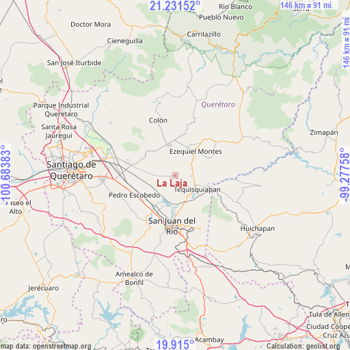
La Laja GPS coordinates[2]
20° 34' 28.848" North, 99° 58' 50.52" West
| Map corner | latitude | longitude |
|---|---|---|
| Upper-left | 21.23152°, | -100.68383° |
| Center: | 20.57468°, | -99.9807° |
| Lower-right: | 19.915°, | -99.27758° |
| Map W x H: | 146.4×146.4 km | = 91×91mi |
| max Lat: | 32.7° ⇑30.5% North |
| La Laja: | 20.57468° |
| min Lat: | ⇓69.5% South 14.53588° |
| min Long | La Laja | max Long |
| -117.105° | -99.9807° | -86.73105° |
| W 36.2%⇐ | ⇒63.8% E |
Elevation
Elevation of La Laja is 1961 m = 6434 ft, and this is 707.3 m = 2321 ft above average elevation for this country.
| Max E: |
3497 m = 11473 ft | 28.4% |
| La Laja | 1961 m 6434 ft | |
| Avg. | 1253.7 m = 4113 ft | |
Min E: |
-1 m = -3 ft | 71.6% |
See also: Mexico elevation on elevation.city.
Geographical zone
La Laja is located in North Torrid zone (between Equator and Tropic of Cancer). Distance of this Northern Tropic circle is 318.2 km =197.7 mi to North.| Distance of | km | miles | from La Laja |
|---|---|---|---|
| North Pole | 7719.4 | 4796.6 | to North |
| Arctic Circle | 5113.5 | 3177.4 | to North |
| Tropic Cancer | 318.2 | 197.7 | to North |
| Equator | 2287.7 | 1421.5 | to South |


Nearby cities:
15 places around La Laja: (largest is in red/bold)
• Bordo Blanco
10.3 km =6.4 mi,  148°
148°
• El Tejocote
7.5 km =4.7 mi,  311°
311°
• Fuentezuelas
2.1 km =1.3 mi,  183°
183°
• La Fuente
6.3 km =3.9 mi,  246°
246°
• La Tortuga
6 km =3.7 mi,  98°
98°
• La Trinidad
6.8 km =4.2 mi,  164°
164°
• La Valla
9.6 km =6 mi,  209°
209°
• Las Cenizas
10.3 km =6.4 mi,  289°
289°
• Los Cerritos
8.7 km =5.4 mi,  260°
260°
• San José de la Laja
4.9 km =3 mi,  6°
6°
• San Nicolás
11.8 km =7.3 mi, 157°
• Santa Rosa Finca
10.6 km =6.6 mi, 8°
• Santa Rosa de Lima
10.1 km =6.3 mi,  1°
1°
• Santillán
5.2 km =3.2 mi,  55°
55°
• Tequisquiapan
10.9 km =6.8 mi,  122°
122°
Sources, notices
• [Note1] Compared only with cities in Mexico existing in our database
• [Src1] Map data: © OpenStreetMap contributors (CC-BY-SA)
• [Src2] Other city data from geonames.org with taken over terms of usage.
• [Src3] Geographical zone / Annual Mean Temperature by Robert A. Rohde @ Wikipedia
