Frontera Hidalgo geodata
Frontera Hidalgo (Chiapas) is a seat of a second-order administrative division; located in Mexico in America/Mexico_City (GMT-6) time zone. With population of 3,519 people, there are 2591 cities with bigger population in this country. Compared to other cities in Mexico, 99.9% of cities are located further ↑North; 94.3% of cities are located further ←West and 81.8% of cities have higher elevation than Frontera Hidalgo. Note1


Frontera Hidalgo GPS coordinates[2]
14° 46' 38.784" North, 92° 10' 38.676" West
| Map corner | latitude | longitude |
|---|---|---|
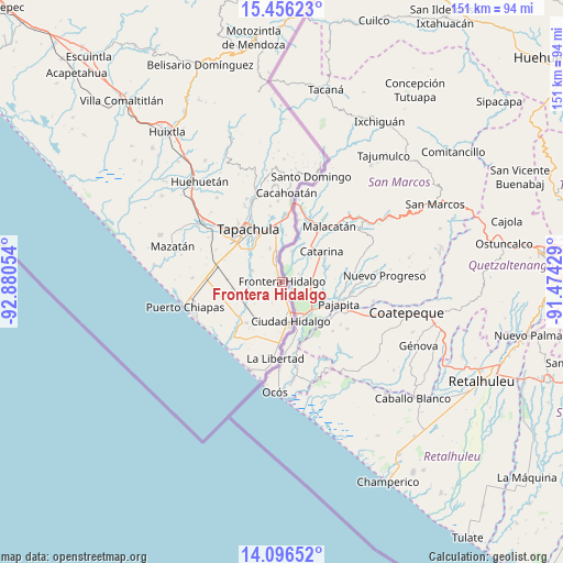
| Upper-left | 15.45623°, | -92.88054° |
| Center: | 14.77744°, | -92.17741° |
| Lower-right: | 14.09652°, | -91.47429° |
| Map W x H: | 151.2×151.2 km | = 94×94mi |
| max Lat: | 32.7° ⇑99.9% North |
| Frontera Hidalgo: | 14.77744° |
| min Lat: | ⇓0.1% South 14.53588° |
| min Long | Frontera Hidalg | max Long |
| -117.105° | -92.17741° | -86.73105° |
| W 94.3%⇐ | ⇒5.7% E |
Elevation
Elevation of Frontera Hidalgo is 72 m = 236 ft, and this is 1181.7 m = 3877 ft below average elevation for this country.
| Max E: |
3497 m = 11473 ft | 81.8% |
| Avg. | 1253.7 m = 4113 ft | |
| Frontera Hidalgo | 72 m = 236 ft | |
Min E: |
-1 m = -3 ft | 18.2% |
See also: Mexico elevation on elevation.city.
Geographical zone
Frontera Hidalgo is located in North Torrid zone (between Equator and Tropic of Cancer). Distance of this Northern Tropic circle is 962.8 km =598.3 mi to North.| Distance of | km | miles | from Frontera Hidalgo |
|---|---|---|---|
| North Pole | 8364 | 5197.1 | to North |
| Arctic Circle | 5758.1 | 3577.9 | to North |
| Tropic Cancer | 962.8 | 598.3 | to North |
| Equator | 1643.1 | 1021 | to South |


Nearby cities:
15 places around Frontera Hidalgo: (largest is in red/bold)
• 2da. Sección de Medio Monte
11.6 km =7.2 mi,  356°
356°
• Cacahoatales
4.2 km =2.6 mi,  317°
317°
• Ciudad Hidalgo
11 km =6.8 mi,  165°
165°
• Dorado Nuevo
12 km =7.5 mi,  197°
197°
• El Arenal
3.8 km =2.4 mi,  342°
342°
• El Campito
11.2 km =7 mi,  178°
178°
• El Sacrificio
11.9 km =7.4 mi,  332°
332°
• Guadalupe Victoria
8.4 km =5.2 mi,  290°
290°
• Ignacio Zaragoza
4.1 km =2.5 mi, 171°
• Los Hules
8.2 km =5.1 mi,  349°
349°
• Metapa
6.7 km =4.2 mi, 346°
• Omoa
8.6 km =5.3 mi, 316°
• Poblado Francisco I. Madero
3.9 km =2.4 mi,  216°
216°
• Texcaltic
2.3 km =1.4 mi, 331°
• Vicente Guerrero
9.3 km =5.8 mi, 340°
Sources, notices
• [Note1] Compared only with cities in Mexico existing in our database
• [Src1] Map data: © OpenStreetMap contributors (CC-BY-SA)
• [Src2] Other city data from geonames.org with taken over terms of usage.
• [Src3] Geographical zone / Annual Mean Temperature by Robert A. Rohde @ Wikipedia
