Vicente Guerrero geodata
Vicente Guerrero (Chiapas) is a populated place; located in Mexico in America/Mexico_City (GMT-6) time zone. With population of 820 people, there are 10646 cities with bigger population in this country. Compared to other cities in Mexico, 99.8% of cities are located further ↑North; 94.1% of cities are located further ←West and 78.1% of cities have higher elevation than Vicente Guerrero. Note1


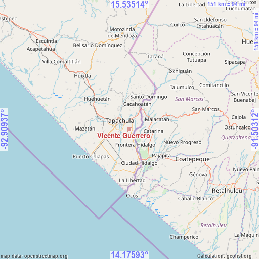
Vicente Guerrero GPS coordinates[2]
14° 51' 23.76" North, 92° 12' 22.464" West
| Map corner | latitude | longitude |
|---|---|---|
| Upper-left | 15.53514°, | -92.90937° |
| Center: | 14.8566°, | -92.20624° |
| Lower-right: | 14.17593°, | -91.50312° |
| Map W x H: | 151.1×151.1 km | = 93.9×93.9mi |
| max Lat: | 32.7° ⇑99.8% North |
| Vicente Guerrero: | 14.8566° |
| min Lat: | ⇓0.2% South 14.53588° |
| min Long | Vicente Guerrer | max Long |
| -117.105° | -92.20624° | -86.73105° |
| W 94.1%⇐ | ⇒5.9% E |
Elevation
Elevation of Vicente Guerrero is 130 m = 427 ft, and this is 1123.7 m = 3687 ft below average elevation for this country.
| Max E: |
3497 m = 11473 ft | 78.1% |
| Avg. | 1253.7 m = 4113 ft | |
| Vicente Guerrero | 130 m = 427 ft | |
Min E: |
-1 m = -3 ft | 21.9% |
See also: Mexico elevation on elevation.city.
Geographical zone
Vicente Guerrero is located in North Torrid zone (between Equator and Tropic of Cancer). Distance of this Northern Tropic circle is 954 km =592.8 mi to North.| Distance of | km | miles | from Vicente Guerrero |
|---|---|---|---|
| North Pole | 8355.2 | 5191.7 | to North |
| Arctic Circle | 5749.3 | 3572.4 | to North |
| Tropic Cancer | 954 | 592.8 | to North |
| Equator | 1651.9 | 1026.4 | to South |


Nearby cities:
15 places around Vicente Guerrero: (largest is in red/bold)
• 2da. Sección de Medio Monte
3.7 km =2.3 mi,  39°
39°
• Cacahoatales
5.7 km =3.5 mi,  177°
177°
• El Arenal
5.6 km =3.5 mi,  159°
159°
• El Sacrificio
2.9 km =1.8 mi,  307°
307°
• Guadalupe Victoria
7.6 km =4.7 mi,  219°
219°
• La Joya
5.4 km =3.4 mi,  278°
278°
• Las Palmeras
7.6 km =4.7 mi, 278°
• Los Encinos
4.5 km =2.8 mi, 311°
• Los Hules
1.8 km =1.1 mi,  113°
113°
• Los Palacios
5.6 km =3.5 mi,  270°
270°
• Metapa
2.7 km =1.7 mi,  145°
145°
• Octavio Paz
6.2 km =3.9 mi, 271°
• Omoa
3.9 km =2.4 mi,  227°
227°
• Tapachula
7.6 km =4.7 mi, 313°
• Texcaltic
7.1 km =4.4 mi, 163°
Sources, notices
• [Note1] Compared only with cities in Mexico existing in our database
• [Src1] Map data: © OpenStreetMap contributors (CC-BY-SA)
• [Src2] Other city data from geonames.org with taken over terms of usage.
• [Src3] Geographical zone / Annual Mean Temperature by Robert A. Rohde @ Wikipedia
