Metapa geodata
Metapa (Chiapas) is a seat of a second-order administrative division; located in Mexico in America/Mexico_City (GMT-6) time zone. With population of 2,610 people, there are 3396 cities with bigger population in this country. Compared to other cities in Mexico, 99.8% of cities are located further ↑North; 94.2% of cities are located further ←West and 79% of cities have higher elevation than Metapa. Note1


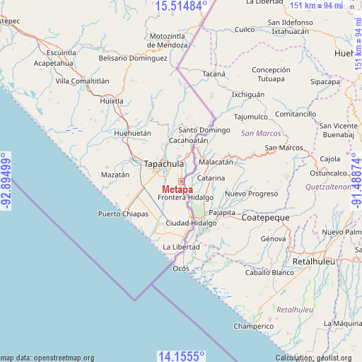
Metapa GPS coordinates[2]
14° 50' 10.464" North, 92° 11' 30.696" West
| Map corner | latitude | longitude |
|---|---|---|
| Upper-left | 15.51484°, | -92.89499° |
| Center: | 14.83624°, | -92.19186° |
| Lower-right: | 14.1555°, | -91.48874° |
| Map W x H: | 151.1×151.1 km | = 93.9×93.9mi |
| max Lat: | 32.7° ⇑99.8% North |
| Metapa: | 14.83624° |
| min Lat: | ⇓0.2% South 14.53588° |
| min Long | Metapa | max Long |
| -117.105° | -92.19186° | -86.73105° |
| W 94.2%⇐ | ⇒5.8% E |
Elevation
Elevation of Metapa is 112 m = 367 ft, and this is 1141.7 m = 3746 ft below average elevation for this country.
| Max E: |
3497 m = 11473 ft | 79% |
| Avg. | 1253.7 m = 4113 ft | |
| Metapa | 112 m = 367 ft | |
Min E: |
-1 m = -3 ft | 21% |
See also: Mexico elevation on elevation.city.
Geographical zone
Metapa is located in North Torrid zone (between Equator and Tropic of Cancer). Distance of this Northern Tropic circle is 956.3 km =594.2 mi to North.| Distance of | km | miles | from Metapa |
|---|---|---|---|
| North Pole | 8357.4 | 5193 | to North |
| Arctic Circle | 5751.5 | 3573.8 | to North |
| Tropic Cancer | 956.3 | 594.2 | to North |
| Equator | 1649.6 | 1025 | to South |


Nearby cities:
15 places around Metapa: (largest is in red/bold)
• 1ra. Sección de Izapa
9.7 km =6 mi,  13°
13°
• 2da. Sección de Medio Monte
5.1 km =3.2 mi, 8°
• Cacahoatales
3.6 km =2.2 mi,  200°
200°
• El Arenal
3 km =1.9 mi,  171°
171°
• El Sacrificio
5.6 km =3.5 mi,  316°
316°
• Frontera Hidalgo
6.7 km =4.2 mi, 166°
• Guadalupe Victoria
7.3 km =4.5 mi,  240°
240°
• La Joya
7.6 km =4.7 mi,  294°
294°
• Los Encinos
7.2 km =4.5 mi, 316°
• Los Hules
1.5 km =0.9 mi,  4°
4°
• Los Palacios
7.5 km =4.7 mi, 288°
• Octavio Paz
8.1 km =5 mi, 287°
• Omoa
4.4 km =2.7 mi,  265°
265°
• Texcaltic
4.6 km =2.9 mi, 173°
• Vicente Guerrero
2.7 km =1.7 mi,  325°
325°
Sources, notices
• [Note1] Compared only with cities in Mexico existing in our database
• [Src1] Map data: © OpenStreetMap contributors (CC-BY-SA)
• [Src2] Other city data from geonames.org with taken over terms of usage.
• [Src3] Geographical zone / Annual Mean Temperature by Robert A. Rohde @ Wikipedia
