Tixpehual geodata
Tixpehual (Yucatán) is a seat of a second-order administrative division; located in Mexico in America/Merida (GMT-6) time zone. With population of 3,470 people, there are 2632 cities with bigger population in this country. Compared to other cities in Mexico, 76.2% of cities are located further ↓South; 98.2% of cities are located further ←West and 94.6% of cities have higher elevation than Tixpehual. Note1


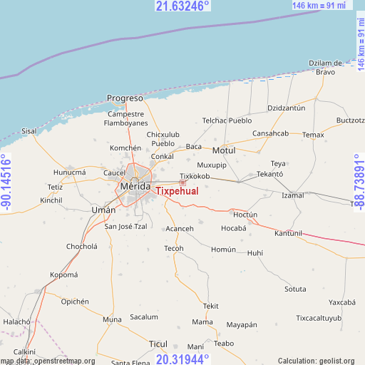
Tixpehual GPS coordinates[2]
20° 58' 38.604" North, 89° 26' 31.308" West
| Map corner | latitude | longitude |
|---|---|---|
| Upper-left | 21.63246°, | -90.14516° |
| Center: | 20.97739°, | -89.44203° |
| Lower-right: | 20.31944°, | -88.73891° |
| Map W x H: | 146×146 km | = 90.7×90.7mi |
| max Lat: | 32.7° ⇑23.8% North |
| Tixpehual: | 20.97739° |
| min Lat: | ⇓76.2% South 14.53588° |
| min Long | Tixpehual | max Long |
| -117.105° | -89.44203° | -86.73105° |
| W 98.2%⇐ | ⇒1.8% E |
Elevation
Elevation of Tixpehual is 14 m = 46 ft, and this is 1239.7 m = 4067 ft below average elevation for this country.
| Max E: |
3497 m = 11473 ft | 94.6% |
| Avg. | 1253.7 m = 4113 ft | |
| Tixpehual | 14 m = 46 ft | |
Min E: |
-1 m = -3 ft | 5.4% |
See also: Mexico elevation on elevation.city.
Geographical zone
Tixpehual is located in North Torrid zone (between Equator and Tropic of Cancer). Distance of this Northern Tropic circle is 273.5 km =169.9 mi to North.| Distance of | km | miles | from Tixpehual |
|---|---|---|---|
| North Pole | 7674.6 | 4768.8 | to North |
| Arctic Circle | 5068.7 | 3149.5 | to North |
| Tropic Cancer | 273.5 | 169.9 | to North |
| Equator | 2332.5 | 1449.3 | to South |


Nearby cities:
15 places around Tixpehual: (largest is in red/bold)
• Chochoh
3.2 km =2 mi,  304°
304°
• Ekmul
9.7 km =6 mi,  98°
98°
• Euan
10.6 km =6.6 mi,  78°
78°
• Nolo
4.1 km =2.5 mi,  28°
28°
• Oncan
4.6 km =2.9 mi,  250°
250°
• Sahé
6.5 km =4 mi,  198°
198°
• San Antonio Millet
4.6 km =2.9 mi, 96°
• San Antonio Tehuitz
11.9 km =7.4 mi,  223°
223°
• Sitpach
9.9 km =6.2 mi, 303°
• Tepich Carrillo
12.6 km =7.8 mi,  207°
207°
• Teya
9.3 km =5.8 mi,  240°
240°
• Ticopó
9.8 km =6.1 mi,  179°
179°
• Tixkokob
5.6 km =3.5 mi,  60°
60°
• Tixkunchell
12.3 km =7.6 mi,  21°
21°
• Yaxkukul
9.6 km =6 mi,  14°
14°
Sources, notices
• [Note1] Compared only with cities in Mexico existing in our database
• [Src1] Map data: © OpenStreetMap contributors (CC-BY-SA)
• [Src2] Other city data from geonames.org with taken over terms of usage.
• [Src3] Geographical zone / Annual Mean Temperature by Robert A. Rohde @ Wikipedia
