Chochoh geodata
Chochoh (Yucatán) is a populated place; located in Mexico in America/Merida (GMT-6) time zone. With population of 597 people, there are 14400 cities with bigger population in this country. Compared to other cities in Mexico, 76.4% of cities are located further ↓South; 98.2% of cities are located further ←West and 97% of cities have higher elevation than Chochoh. Note1


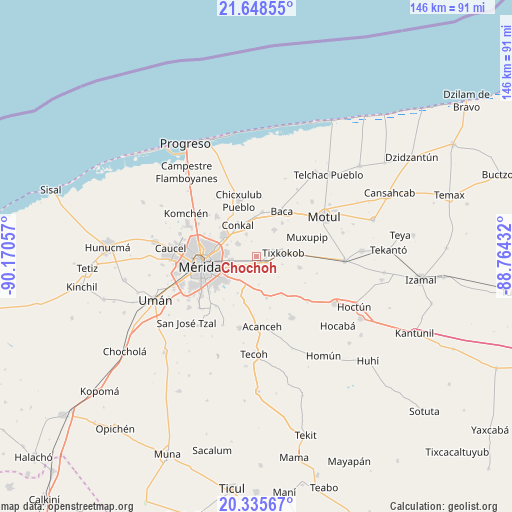
Chochoh GPS coordinates[2]
20° 59' 36.78" North, 89° 28' 2.784" West
| Map corner | latitude | longitude |
|---|---|---|
| Upper-left | 21.64855°, | -90.17057° |
| Center: | 20.99355°, | -89.46744° |
| Lower-right: | 20.33567°, | -88.76432° |
| Map W x H: | 146×146 km | = 90.7×90.7mi |
| max Lat: | 32.7° ⇑23.6% North |
| Chochoh: | 20.99355° |
| min Lat: | ⇓76.4% South 14.53588° |
| min Long | Chochoh | max Long |
| -117.105° | -89.46744° | -86.73105° |
| W 98.2%⇐ | ⇒1.8% E |
Elevation
Elevation of Chochoh is 10 m = 33 ft, and this is 1243.7 m = 4080 ft below average elevation for this country.
| Max E: |
3497 m = 11473 ft | 97% |
| Avg. | 1253.7 m = 4113 ft | |
| Chochoh | 10 m = 33 ft | |
Min E: |
-1 m = -3 ft | 3% |
See also: Mexico elevation on elevation.city.
Geographical zone
Chochoh is located in North Torrid zone (between Equator and Tropic of Cancer). Distance of this Northern Tropic circle is 271.7 km =168.8 mi to North.| Distance of | km | miles | from Chochoh |
|---|---|---|---|
| North Pole | 7672.8 | 4767.7 | to North |
| Arctic Circle | 5066.9 | 3148.4 | to North |
| Tropic Cancer | 271.7 | 168.8 | to North |
| Equator | 2334.3 | 1450.5 | to South |


Nearby cities:
15 places around Chochoh: (largest is in red/bold)
• Cholul
10.9 km =6.8 mi,  299°
299°
• Conkal
10.4 km =6.5 mi,  328°
328°
• Kanasín
11.5 km =7.1 mi,  235°
235°
• Nolo
4.9 km =3 mi,  68°
68°
• Oncan
3.8 km =2.4 mi,  207°
207°
• Sahé
8 km =5 mi,  176°
176°
• San Antonio Millet
7.6 km =4.7 mi,  107°
107°
• San Antonio Tehuitz
11.8 km =7.3 mi, 207°
• Sitpach
6.7 km =4.2 mi, 303°
• Tekát
11.5 km =7.1 mi,  356°
356°
• Teya
8.4 km =5.2 mi,  220°
220°
• Tixkokob
7.6 km =4.7 mi,  82°
82°
• Tixkunchell
12 km =7.5 mi,  37°
37°
• Tixpehual
3.2 km =2 mi,  124°
124°
• Yaxkukul
9 km =5.6 mi,  33°
33°
Sources, notices
• [Note1] Compared only with cities in Mexico existing in our database
• [Src1] Map data: © OpenStreetMap contributors (CC-BY-SA)
• [Src2] Other city data from geonames.org with taken over terms of usage.
• [Src3] Geographical zone / Annual Mean Temperature by Robert A. Rohde @ Wikipedia
