Tixkunchell geodata
Tixkunchell (Yucatán) is a populated place; located in Mexico in America/Merida (GMT-6) time zone. With population of 799 people, there are 10920 cities with bigger population in this country. Compared to other cities in Mexico, 77.6% of cities are located further ↓South; 98.3% of cities are located further ←West and 97% of cities have higher elevation than Tixkunchell. Note1


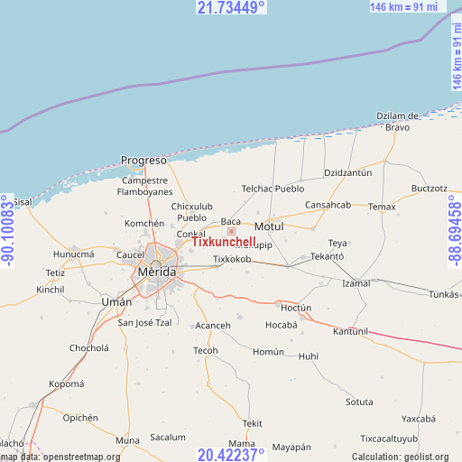
Tixkunchell GPS coordinates[2]
21° 4' 47.568" North, 89° 23' 51.72" West
| Map corner | latitude | longitude |
|---|---|---|
| Upper-left | 21.73449°, | -90.10083° |
| Center: | 21.07988°, | -89.3977° |
| Lower-right: | 20.42237°, | -88.69458° |
| Map W x H: | 145.9×145.9 km | = 90.7×90.7mi |
| max Lat: | 32.7° ⇑22.4% North |
| Tixkunchell: | 21.07988° |
| min Lat: | ⇓77.6% South 14.53588° |
| min Long | Tixkunchell | max Long |
| -117.105° | -89.3977° | -86.73105° |
| W 98.3%⇐ | ⇒1.7% E |
Elevation
Elevation of Tixkunchell is 10 m = 33 ft, and this is 1243.7 m = 4080 ft below average elevation for this country.
| Max E: |
3497 m = 11473 ft | 97% |
| Avg. | 1253.7 m = 4113 ft | |
| Tixkunchell | 10 m = 33 ft | |
Min E: |
-1 m = -3 ft | 3% |
See also: Mexico elevation on elevation.city.
Geographical zone
Tixkunchell is located in North Torrid zone (between Equator and Tropic of Cancer). Distance of this Northern Tropic circle is 262.1 km =162.9 mi to North.| Distance of | km | miles | from Tixkunchell |
|---|---|---|---|
| North Pole | 7663.2 | 4761.7 | to North |
| Arctic Circle | 5057.3 | 3142.5 | to North |
| Tropic Cancer | 262.1 | 162.9 | to North |
| Equator | 2343.9 | 1456.4 | to South |


Nearby cities:
15 places around Tixkunchell: (largest is in red/bold)
• Baca
3.2 km =2 mi,  358°
358°
• Chochoh
12 km =7.5 mi,  217°
217°
• Euan
10.9 km =6.8 mi,  148°
148°
• Ixil
11.9 km =7.4 mi,  312°
312°
• Kini
10.4 km =6.5 mi,  53°
53°
• Mococha
6.4 km =4 mi,  297°
297°
• Motul
12 km =7.5 mi,  81°
81°
• Muxupip
8.3 km =5.2 mi,  120°
120°
• Nolo
8.3 km =5.2 mi,  198°
198°
• Sacapuc
10.5 km =6.5 mi,  24°
24°
• San Antonio Millet
11.9 km =7.4 mi,  179°
179°
• Tekát
8.1 km =5 mi,  283°
283°
• Tixkokob
8.6 km =5.3 mi, 178°
• Tixpehual
12.3 km =7.6 mi, 201°
• Yaxkukul
3 km =1.9 mi,  227°
227°
Sources, notices
• [Note1] Compared only with cities in Mexico existing in our database
• [Src1] Map data: © OpenStreetMap contributors (CC-BY-SA)
• [Src2] Other city data from geonames.org with taken over terms of usage.
• [Src3] Geographical zone / Annual Mean Temperature by Robert A. Rohde @ Wikipedia
