El Cajón geodata
El Cajón (Hidalgo) is a populated place; located in Mexico in America/Mexico_City (GMT-6) time zone. With population of 760 people, there are 11527 cities with bigger population in this country. Compared to other cities in Mexico, 65.3% of cities are located further ↓South; 59% of cities are located further →East and 78.8% of cities have lower elevation than El Cajón. Note1


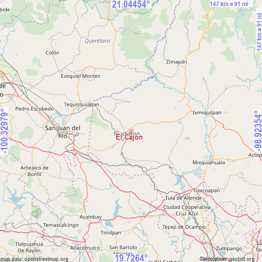
El Cajón GPS coordinates[2]
20° 23' 12.768" North, 99° 37' 35.976" West
| Map corner | latitude | longitude |
|---|---|---|
| Upper-left | 21.04454°, | -100.32979° |
| Center: | 20.38688°, | -99.62666° |
| Lower-right: | 19.7264°, | -98.92354° |
| Map W x H: | 146.6×146.6 km | = 91.1×91.1mi |
| max Lat: | 32.7° ⇑34.7% North |
| El Cajón: | 20.38688° |
| min Lat: | ⇓65.3% South 14.53588° |
| min Long | El Cajón | max Long |
| -117.105° | -99.62666° | -86.73105° |
| W 41%⇐ | ⇒59% E |
Elevation
Elevation of El Cajón is 2107 m = 6913 ft, and this is 853.3 m = 2800 ft above average elevation for this country.
| Max E: |
3497 m = 11473 ft | 21.2% |
| El Cajón | 2107 m 6913 ft | |
| Avg. | 1253.7 m = 4113 ft | |
Min E: |
-1 m = -3 ft | 78.8% |
See also: Mexico elevation on elevation.city.
Geographical zone
El Cajón is located in North Torrid zone (between Equator and Tropic of Cancer). Distance of this Northern Tropic circle is 339.1 km =210.7 mi to North.| Distance of | km | miles | from El Cajón |
|---|---|---|---|
| North Pole | 7740.3 | 4809.6 | to North |
| Arctic Circle | 5134.4 | 3190.4 | to North |
| Tropic Cancer | 339.1 | 210.7 | to North |
| Equator | 2266.8 | 1408.5 | to South |


Nearby cities:
15 places around El Cajón: (largest is in red/bold)
• Bondojito
10 km =6.2 mi,  309°
309°
• Dantzibojay
7.2 km =4.5 mi,  36°
36°
• Dongoteay
6.4 km =4 mi,  240°
240°
• Huichapan
2.6 km =1.6 mi, 242°
• Jonacapa
11.1 km =6.9 mi,  61°
61°
• La Sabinita
2.8 km =1.7 mi,  196°
196°
• Mamithi
4.2 km =2.6 mi, 308°
• Maney
6 km =3.7 mi,  275°
275°
• Maxtha
7.3 km =4.5 mi,  18°
18°
• Pedregoso
6.3 km =3.9 mi,  194°
194°
• Sabina Grande
1.3 km =0.8 mi,  171°
171°
• San José Atlán
7.3 km =4.5 mi,  222°
222°
• San Miguel Caltepantla
10.5 km =6.5 mi,  2°
2°
• Taguí
6.6 km =4.1 mi,  347°
347°
• Zothé
9.5 km =5.9 mi,  258°
258°
Sources, notices
• [Note1] Compared only with cities in Mexico existing in our database
• [Src1] Map data: © OpenStreetMap contributors (CC-BY-SA)
• [Src2] Other city data from geonames.org with taken over terms of usage.
• [Src3] Geographical zone / Annual Mean Temperature by Robert A. Rohde @ Wikipedia
