San Miguel Caltepantla geodata
San Miguel Caltepantla (Hidalgo) is a populated place; located in Mexico in America/Mexico_City (GMT-6) time zone. With population of 673 people, there are 12911 cities with bigger population in this country. Compared to other cities in Mexico, 67.4% of cities are located further ↓South; 58.9% of cities are located further →East and 66.1% of cities have lower elevation than San Miguel Caltepantla. Note1


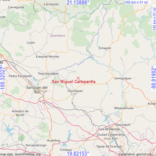
San Miguel Caltepantla GPS coordinates[2]
20° 28' 53.796" North, 99° 37' 19.704" West
| Map corner | latitude | longitude |
|---|---|---|
| Upper-left | 21.13886°, | -100.32527° |
| Center: | 20.48161°, | -99.62214° |
| Lower-right: | 19.82153°, | -98.91902° |
| Map W x H: | 146.5×146.5 km | = 91×91mi |
| max Lat: | 32.7° ⇑32.6% North |
| San Miguel Caltepantla: | 20.48161° |
| min Lat: | ⇓67.4% South 14.53588° |
| min Long | San Miguel Calt | max Long |
| -117.105° | -99.62214° | -86.73105° |
| W 41.1%⇐ | ⇒58.9% E |
Elevation
Elevation of San Miguel Caltepantla is 1854 m = 6083 ft, and this is 600.3 m = 1969 ft above average elevation for this country.
| Max E: |
3497 m = 11473 ft | 33.9% |
| San Miguel Caltepantla | 1854 m 6083 ft | |
| Avg. | 1253.7 m = 4113 ft | |
Min E: |
-1 m = -3 ft | 66.1% |
See also: Mexico elevation on elevation.city.
Geographical zone
San Miguel Caltepantla is located in North Torrid zone (between Equator and Tropic of Cancer). Distance of this Northern Tropic circle is 328.6 km =204.2 mi to North.| Distance of | km | miles | from San Miguel Caltepantla |
|---|---|---|---|
| North Pole | 7729.7 | 4803 | to North |
| Arctic Circle | 5123.8 | 3183.8 | to North |
| Tropic Cancer | 328.6 | 204.2 | to North |
| Equator | 2277.3 | 1415 | to South |


Nearby cities:
15 places around San Miguel Caltepantla: (largest is in red/bold)
• Apartadero
7.3 km =4.5 mi,  71°
71°
• Atengo
10.4 km =6.5 mi,  272°
272°
• Bomanxotha
6 km =3.7 mi,  308°
308°
• Bondojito
9.1 km =5.7 mi,  242°
242°
• Dantzibojay
6 km =3.7 mi,  141°
141°
• El Cajón
10.5 km =6.5 mi,  182°
182°
• El Riíto
10.6 km =6.6 mi,  355°
355°
• Gandhó
9.8 km =6.1 mi,  316°
316°
• La Mesilla
5.8 km =3.6 mi,  278°
278°
• Mamithi
8.8 km =5.5 mi,  205°
205°
• Maxtha
4 km =2.5 mi,  153°
153°
• Pañhé
8.9 km =5.5 mi,  299°
299°
• Taguí
4.4 km =2.7 mi,  204°
204°
• Tecozautla
5.9 km =3.7 mi,  347°
347°
• Tenzabhí
3.1 km =1.9 mi,  327°
327°
Sources, notices
• [Note1] Compared only with cities in Mexico existing in our database
• [Src1] Map data: © OpenStreetMap contributors (CC-BY-SA)
• [Src2] Other city data from geonames.org with taken over terms of usage.
• [Src3] Geographical zone / Annual Mean Temperature by Robert A. Rohde @ Wikipedia
