Maxtha geodata
Maxtha (Hidalgo) is a populated place; located in Mexico in America/Mexico_City (GMT-6) time zone. With population of 703 people, there are 12379 cities with bigger population in this country. Compared to other cities in Mexico, 66.7% of cities are located further ↓South; 58.7% of cities are located further →East and 76.2% of cities have lower elevation than Maxtha. Note1


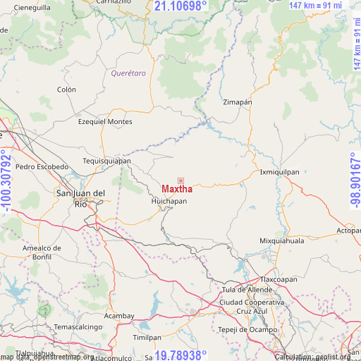
Maxtha GPS coordinates[2]
20° 26' 58.524" North, 99° 36' 17.244" West
| Map corner | latitude | longitude |
|---|---|---|
| Upper-left | 21.10698°, | -100.30792° |
| Center: | 20.44959°, | -99.60479° |
| Lower-right: | 19.78938°, | -98.90167° |
| Map W x H: | 146.5×146.5 km | = 91×91mi |
| max Lat: | 32.7° ⇑33.3% North |
| Maxtha: | 20.44959° |
| min Lat: | ⇓66.7% South 14.53588° |
| min Long | Maxtha | max Long |
| -117.105° | -99.60479° | -86.73105° |
| W 41.3%⇐ | ⇒58.7% E |
Elevation
Elevation of Maxtha is 2051 m = 6729 ft, and this is 797.3 m = 2616 ft above average elevation for this country.
| Max E: |
3497 m = 11473 ft | 23.8% |
| Maxtha | 2051 m 6729 ft | |
| Avg. | 1253.7 m = 4113 ft | |
Min E: |
-1 m = -3 ft | 76.2% |
See also: Mexico elevation on elevation.city.
Geographical zone
Maxtha is located in North Torrid zone (between Equator and Tropic of Cancer). Distance of this Northern Tropic circle is 332.1 km =206.4 mi to North.| Distance of | km | miles | from Maxtha |
|---|---|---|---|
| North Pole | 7733.3 | 4805.2 | to North |
| Arctic Circle | 5127.4 | 3186 | to North |
| Tropic Cancer | 332.1 | 206.4 | to North |
| Equator | 2273.8 | 1412.9 | to South |


Nearby cities:
15 places around Maxtha: (largest is in red/bold)
• Apartadero
7.8 km =4.8 mi,  41°
41°
• Bomanxotha
9.8 km =6.1 mi,  318°
318°
• Bondojito
10 km =6.2 mi,  266°
266°
• Dantzibojay
2.3 km =1.4 mi,  120°
120°
• El Cajón
7.3 km =4.5 mi,  198°
198°
• Huichapan
9.4 km =5.8 mi,  209°
209°
• Jonacapa
7.7 km =4.8 mi,  103°
103°
• La Mesilla
8.7 km =5.4 mi,  300°
300°
• La Sabinita
10.1 km =6.3 mi, 197°
• Mamithi
7.1 km =4.4 mi,  231°
231°
• Sabina Grande
8.5 km =5.3 mi,  194°
194°
• San Miguel Caltepantla
4 km =2.5 mi,  333°
333°
• Taguí
3.7 km =2.3 mi,  262°
262°
• Tecozautla
9.8 km =6.1 mi,  341°
341°
• Tenzabhí
7.1 km =4.4 mi, 330°
Sources, notices
• [Note1] Compared only with cities in Mexico existing in our database
• [Src1] Map data: © OpenStreetMap contributors (CC-BY-SA)
• [Src2] Other city data from geonames.org with taken over terms of usage.
• [Src3] Geographical zone / Annual Mean Temperature by Robert A. Rohde @ Wikipedia
