Mamithi geodata
Mamithi (Hidalgo) is a populated place; located in Mexico in America/Mexico_City (GMT-6) time zone. With population of 1,875 people, there are 4637 cities with bigger population in this country. Compared to other cities in Mexico, 65.9% of cities are located further ↓South; 59.6% of cities are located further →East and 75.3% of cities have lower elevation than Mamithi. Note1


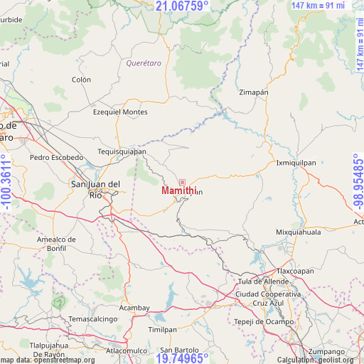
Mamithi GPS coordinates[2]
20° 24' 36.108" North, 99° 39' 28.692" West
| Map corner | latitude | longitude |
|---|---|---|
| Upper-left | 21.06759°, | -100.3611° |
| Center: | 20.41003°, | -99.65797° |
| Lower-right: | 19.74965°, | -98.95485° |
| Map W x H: | 146.5×146.5 km | = 91×91mi |
| max Lat: | 32.7° ⇑34.1% North |
| Mamithi: | 20.41003° |
| min Lat: | ⇓65.9% South 14.53588° |
| min Long | Mamithi | max Long |
| -117.105° | -99.65797° | -86.73105° |
| W 40.4%⇐ | ⇒59.6% E |
Elevation
Elevation of Mamithi is 2035 m = 6677 ft, and this is 781.3 m = 2563 ft above average elevation for this country.
| Max E: |
3497 m = 11473 ft | 24.7% |
| Mamithi | 2035 m 6677 ft | |
| Avg. | 1253.7 m = 4113 ft | |
Min E: |
-1 m = -3 ft | 75.3% |
See also: Mexico elevation on elevation.city.
Geographical zone
Mamithi is located in North Torrid zone (between Equator and Tropic of Cancer). Distance of this Northern Tropic circle is 336.5 km =209.1 mi to North.| Distance of | km | miles | from Mamithi |
|---|---|---|---|
| North Pole | 7737.7 | 4808 | to North |
| Arctic Circle | 5131.8 | 3188.8 | to North |
| Tropic Cancer | 336.5 | 209.1 | to North |
| Equator | 2269.4 | 1410.1 | to South |


Nearby cities:
15 places around Mamithi: (largest is in red/bold)
• Bondojito
5.8 km =3.6 mi,  310°
310°
• Dantzibojay
8.2 km =5.1 mi,  66°
66°
• Dongoteay
6.2 km =3.9 mi,  201°
201°
• El Cajón
4.2 km =2.6 mi,  128°
128°
• Huichapan
3.9 km =2.4 mi,  165°
165°
• La Mesilla
9 km =5.6 mi,  347°
347°
• La Sabinita
5.8 km =3.6 mi,  154°
154°
• Maney
3.3 km =2.1 mi,  232°
232°
• Maxtha
7.1 km =4.4 mi,  51°
51°
• Pedregoso
8.9 km =5.5 mi, 169°
• Sabina Grande
5.2 km =3.2 mi,  138°
138°
• San José Atlán
8.1 km =5 mi,  191°
191°
• San Miguel Caltepantla
8.8 km =5.5 mi,  25°
25°
• Taguí
4.3 km =2.7 mi, 25°
• Zothé
7.5 km =4.7 mi, 233°
Sources, notices
• [Note1] Compared only with cities in Mexico existing in our database
• [Src1] Map data: © OpenStreetMap contributors (CC-BY-SA)
• [Src2] Other city data from geonames.org with taken over terms of usage.
• [Src3] Geographical zone / Annual Mean Temperature by Robert A. Rohde @ Wikipedia
