Pedregoso geodata
Pedregoso (Hidalgo) is a populated place; located in Mexico in America/Mexico_City (GMT-6) time zone. With population of 889 people, there are 9811 cities with bigger population in this country. Compared to other cities in Mexico, 64.2% of cities are located further ↓South; 59.3% of cities are located further →East and 85.8% of cities have lower elevation than Pedregoso. Note1


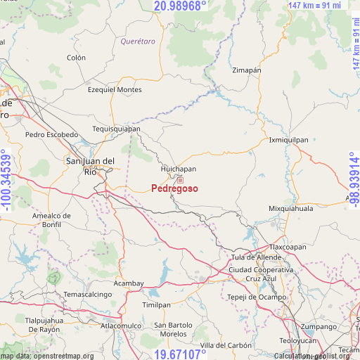
Pedregoso GPS coordinates[2]
20° 19' 54.408" North, 99° 38' 32.136" West
| Map corner | latitude | longitude |
|---|---|---|
| Upper-left | 20.98968°, | -100.34539° |
| Center: | 20.33178°, | -99.64226° |
| Lower-right: | 19.67107°, | -98.93914° |
| Map W x H: | 146.6×146.6 km | = 91.1×91.1mi |
| max Lat: | 32.7° ⇑35.8% North |
| Pedregoso: | 20.33178° |
| min Lat: | ⇓64.2% South 14.53588° |
| min Long | Pedregoso | max Long |
| -117.105° | -99.64226° | -86.73105° |
| W 40.7%⇐ | ⇒59.3% E |
Elevation
Elevation of Pedregoso is 2277 m = 7470 ft, and this is 1023.3 m = 3357 ft above average elevation for this country.
| Max E: |
3497 m = 11473 ft | 14.2% |
| Pedregoso | 2277 m 7470 ft | |
| Avg. | 1253.7 m = 4113 ft | |
Min E: |
-1 m = -3 ft | 85.8% |
See also: Mexico elevation on elevation.city.
Geographical zone
Pedregoso is located in North Torrid zone (between Equator and Tropic of Cancer). Distance of this Northern Tropic circle is 345.2 km =214.5 mi to North.| Distance of | km | miles | from Pedregoso |
|---|---|---|---|
| North Pole | 7746.4 | 4813.4 | to North |
| Arctic Circle | 5140.5 | 3194.2 | to North |
| Tropic Cancer | 345.2 | 214.5 | to North |
| Equator | 2260.7 | 1404.7 | to South |


Nearby cities:
15 places around Pedregoso: (largest is in red/bold)
• Dantzibojay
13.3 km =8.3 mi,  26°
26°
• Dongoteay
4.9 km =3 mi,  307°
307°
• El Cajón
6.3 km =3.9 mi,  14°
14°
• El Jagüey
9.9 km =6.2 mi,  163°
163°
• El Saucillo
6.8 km =4.2 mi,  253°
253°
• Huichapan
5 km =3.1 mi,  352°
352°
• La Sabinita
3.6 km =2.2 mi, 13°
• Mamithi
8.9 km =5.5 mi, 349°
• Maney
8 km =5 mi,  327°
327°
• Nopala de Villagran
8.9 km =5.5 mi,  182°
182°
• Sabina Grande
5.2 km =3.2 mi,  20°
20°
• San José Atlán
3.4 km =2.1 mi,  282°
282°
• San Sebastián Tenochtitlán
7.5 km =4.7 mi,  220°
220°
• Taguí
12.6 km =7.8 mi,  1°
1°
• Zothé
8.7 km =5.4 mi,  298°
298°
Sources, notices
• [Note1] Compared only with cities in Mexico existing in our database
• [Src1] Map data: © OpenStreetMap contributors (CC-BY-SA)
• [Src2] Other city data from geonames.org with taken over terms of usage.
• [Src3] Geographical zone / Annual Mean Temperature by Robert A. Rohde @ Wikipedia
