Vicente Guerrero (El Aguacate) geodata
Vicente Guerrero (El Aguacate) (Veracruz) is a populated place; located in Mexico in America/Mexico_City (GMT-6) time zone. With population of 874 people, there are 9993 cities with bigger population in this country. Compared to other cities in Mexico, 75.9% of cities are located further ↑North; 82.9% of cities are located further ←West and 94% of cities have higher elevation than Vicente Guerrero (El Aguacate). Note1
Current local time in Vicente Guerrero (El Aguacate):
05:21 AM, WednesdayDifference from your time zone: hours


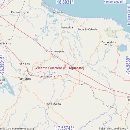
Vicente Guerrero (El Aguacate) GPS coordinates[2]
18° 13' 35.58" North, 95° 41' 13.272" West
| Map corner | latitude | longitude |
|---|---|---|
| Upper-left | 18.8931°, | -96.39015° |
| Center: | 18.22655°, | -95.68702° |
| Lower-right: | 17.55743°, | -94.9839° |
| Map W x H: | 148.5×148.5 km | = 92.3×92.3mi |
| max Lat: | 32.7° ⇑75.9% North |
| Vicente Guerrero (El Aguacate): | 18.22655° |
| min Lat: | ⇓24.1% South 14.53588° |
| min Long | Vicente Guerrer | max Long |
| -117.105° | -95.68702° | -86.73105° |
| W 82.9%⇐ | ⇒17.1% E |
Elevation
Elevation of Vicente Guerrero (El Aguacate) is 15 m = 49 ft, and this is 1238.7 m = 4064 ft below average elevation for this country.
| Max E: |
3497 m = 11473 ft | 94% |
| Avg. | 1253.7 m = 4113 ft | |
| Vicente Guerrero (El Aguacate) | 15 m = 49 ft | |
Min E: |
-1 m = -3 ft | 6% |
See also: Mexico elevation on elevation.city.
Geographical zone
Vicente Guerrero (El Aguacate) is located in North Torrid zone (between Equator and Tropic of Cancer). Distance of this Northern Tropic circle is 579.3 km =360 mi to North.| Distance of | km | miles | from Vicente Guerrero (El Aguacate) |
|---|---|---|---|
| North Pole | 7980.5 | 4958.9 | to North |
| Arctic Circle | 5374.6 | 3339.6 | to North |
| Tropic Cancer | 579.3 | 360 | to North |
| Equator | 2026.6 | 1259.3 | to South |


Nearby cities:
15 places around Vicente Guerrero (El Aguacate): (largest is in red/bold)
• Arroyo del Soldado (Arroyo del Obispo)
13.9 km =8.6 mi,  315°
315°
• Carlos A. Carrillo
18 km =11.2 mi,  336°
336°
• Cujuliapan
4.5 km =2.8 mi,  128°
128°
• Curazao
13.8 km =8.6 mi,  179°
179°
• El Maguey
17.2 km =10.7 mi, 184°
• Estación Dobladero
15 km =9.3 mi,  213°
213°
• Juan García
7 km =4.3 mi,  42°
42°
• Las Mesas
5 km =3.1 mi,  227°
227°
• Las Sabanetas
18.1 km =11.2 mi, 232°
• Lindavista
18 km =11.2 mi, 211°
• Mata de Caña
16 km =9.9 mi,  265°
265°
• Nuevo Potrero
15.9 km =9.9 mi,  148°
148°
• Tesechoacan
10.4 km =6.5 mi,  162°
162°
• Tilapa
12.4 km =7.7 mi, 321°
• Villa Azueta
17.2 km =10.7 mi,  188°
188°
Sources, notices
• [Note1] Compared only with cities in Mexico existing in our database
• [Src1] Map data: © OpenStreetMap contributors (CC-BY-SA)
• [Src2] Other city data from geonames.org with taken over terms of usage.
• [Src3] Geographical zone / Annual Mean Temperature by Robert A. Rohde @ Wikipedia
