Villa Azueta geodata
Villa Azueta (Veracruz) is a populated place; located in Mexico in America/Mexico_City (GMT-6) time zone. With population of 6,754 people, there are 1385 cities with bigger population in this country. Compared to other cities in Mexico, 77.8% of cities are located further ↑North; 82.9% of cities are located further ←West and 87.5% of cities have higher elevation than Villa Azueta. Note1


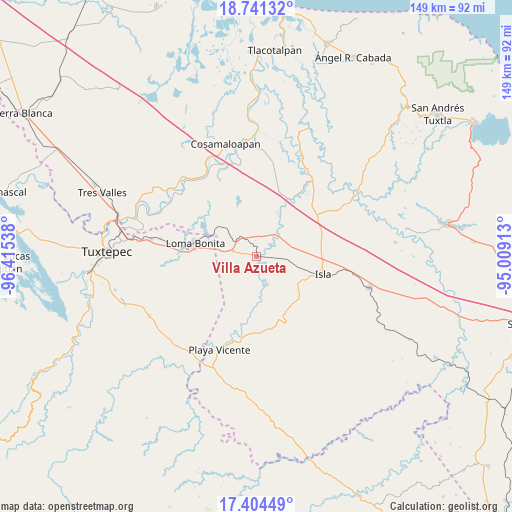
Villa Azueta GPS coordinates[2]
18° 4' 27.048" North, 95° 42' 44.1" West
| Map corner | latitude | longitude |
|---|---|---|
| Upper-left | 18.74132°, | -96.41538° |
| Center: | 18.07418°, | -95.71225° |
| Lower-right: | 17.40449°, | -95.00913° |
| Map W x H: | 148.6×148.6 km | = 92.3×92.3mi |
| max Lat: | 32.7° ⇑77.8% North |
| Villa Azueta: | 18.07418° |
| min Lat: | ⇓22.2% South 14.53588° |
| min Long | Villa Azueta | max Long |
| -117.105° | -95.71225° | -86.73105° |
| W 82.9%⇐ | ⇒17.1% E |
Elevation
Elevation of Villa Azueta is 32 m = 105 ft, and this is 1221.7 m = 4008 ft below average elevation for this country.
| Max E: |
3497 m = 11473 ft | 87.5% |
| Avg. | 1253.7 m = 4113 ft | |
| Villa Azueta | 32 m = 105 ft | |
Min E: |
-1 m = -3 ft | 12.5% |
See also: Mexico elevation on elevation.city.
Geographical zone
Villa Azueta is located in North Torrid zone (between Equator and Tropic of Cancer). Distance of this Northern Tropic circle is 596.3 km =370.5 mi to North.| Distance of | km | miles | from Villa Azueta |
|---|---|---|---|
| North Pole | 7997.4 | 4969.4 | to North |
| Arctic Circle | 5391.5 | 3350.1 | to North |
| Tropic Cancer | 596.3 | 370.5 | to North |
| Equator | 2009.7 | 1248.8 | to South |


Nearby cities:
15 places around Villa Azueta: (largest is in red/bold)
• Cujuliapan
15.5 km =9.6 mi,  23°
23°
• Curazao
4.1 km =2.5 mi,  41°
41°
• El Maguey
1.3 km =0.8 mi,  100°
100°
• El Marcial
10.8 km =6.7 mi,  163°
163°
• Estación Dobladero
7.3 km =4.5 mi,  308°
308°
• Las Mesas
13.7 km =8.5 mi,  355°
355°
• Las Sabanetas
13 km =8.1 mi,  296°
296°
• Lindavista
6.9 km =4.3 mi,  283°
283°
• Loma Alta
13.4 km =8.3 mi,  142°
142°
• Loma Bonita
18 km =11.2 mi, 281°
• Mazoco
10.6 km =6.6 mi,  94°
94°
• Nuevo Potrero
11.5 km =7.1 mi,  72°
72°
• San Jerónimo
10 km =6.2 mi,  172°
172°
• Tesechoacan
9.1 km =5.7 mi, 38°
• Vicente Guerrero (El Aguacate)
17.2 km =10.7 mi,  8°
8°
Sources, notices
• [Note1] Compared only with cities in Mexico existing in our database
• [Src1] Map data: © OpenStreetMap contributors (CC-BY-SA)
• [Src2] Other city data from geonames.org with taken over terms of usage.
• [Src3] Geographical zone / Annual Mean Temperature by Robert A. Rohde @ Wikipedia
