Tesechoacan geodata
Tesechoacan (Veracruz) is a populated place; located in Mexico in America/Mexico_City (GMT-6) time zone. With population of 6,783 people, there are 1377 cities with bigger population in this country. Compared to other cities in Mexico, 77.1% of cities are located further ↑North; 83% of cities are located further ←West and 92.5% of cities have higher elevation than Tesechoacan. Note1


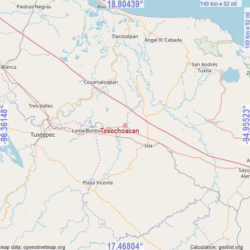
Tesechoacan GPS coordinates[2]
18° 8' 14.964" North, 95° 39' 30.06" West
| Map corner | latitude | longitude |
|---|---|---|
| Upper-left | 18.80439°, | -96.36148° |
| Center: | 18.13749°, | -95.65835° |
| Lower-right: | 17.46804°, | -94.95523° |
| Map W x H: | 148.6×148.6 km | = 92.3×92.3mi |
| max Lat: | 32.7° ⇑77.1% North |
| Tesechoacan: | 18.13749° |
| min Lat: | ⇓22.9% South 14.53588° |
| min Long | Tesechoacan | max Long |
| -117.105° | -95.65835° | -86.73105° |
| W 83%⇐ | ⇒17% E |
Elevation
Elevation of Tesechoacan is 18 m = 59 ft, and this is 1235.7 m = 4054 ft below average elevation for this country.
| Max E: |
3497 m = 11473 ft | 92.5% |
| Avg. | 1253.7 m = 4113 ft | |
| Tesechoacan | 18 m = 59 ft | |
Min E: |
-1 m = -3 ft | 7.5% |
See also: Mexico elevation on elevation.city.
Geographical zone
Tesechoacan is located in North Torrid zone (between Equator and Tropic of Cancer). Distance of this Northern Tropic circle is 589.2 km =366.1 mi to North.| Distance of | km | miles | from Tesechoacan |
|---|---|---|---|
| North Pole | 7990.4 | 4965 | to North |
| Arctic Circle | 5384.5 | 3345.8 | to North |
| Tropic Cancer | 589.2 | 366.1 | to North |
| Equator | 2016.7 | 1253.1 | to South |


Nearby cities:
15 places around Tesechoacan: (largest is in red/bold)
• Cujuliapan
7.2 km =4.5 mi,  3°
3°
• Curazao
4.9 km =3 mi,  217°
217°
• El Maguey
8.5 km =5.3 mi,  211°
211°
• El Marcial
17.6 km =10.9 mi,  188°
188°
• Estación Dobladero
11.7 km =7.3 mi,  257°
257°
• Juan García
15.2 km =9.4 mi,  6°
6°
• Las Mesas
9.4 km =5.8 mi,  314°
314°
• Las Sabanetas
17.4 km =10.8 mi,  266°
266°
• Lindavista
13.5 km =8.4 mi,  246°
246°
• Loma Alta
17.8 km =11.1 mi,  171°
171°
• Mazoco
9.3 km =5.8 mi,  148°
148°
• Nuevo Potrero
6.4 km =4 mi,  124°
124°
• San Jerónimo
17.6 km =10.9 mi, 194°
• Vicente Guerrero (El Aguacate)
10.4 km =6.5 mi,  342°
342°
• Villa Azueta
9.1 km =5.7 mi, 218°
Sources, notices
• [Note1] Compared only with cities in Mexico existing in our database
• [Src1] Map data: © OpenStreetMap contributors (CC-BY-SA)
• [Src2] Other city data from geonames.org with taken over terms of usage.
• [Src3] Geographical zone / Annual Mean Temperature by Robert A. Rohde @ Wikipedia
