Nuevo Potrero geodata
Nuevo Potrero (Veracruz) is a populated place; located in Mexico in America/Mexico_City (GMT-6) time zone. With population of 553 people, there are 15422 cities with bigger population in this country. Compared to other cities in Mexico, 77.5% of cities are located further ↑North; 83.1% of cities are located further ←West and 92.1% of cities have higher elevation than Nuevo Potrero. Note1


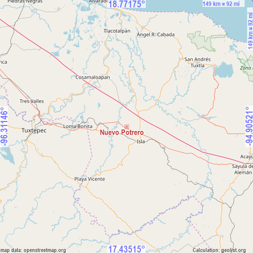
Nuevo Potrero GPS coordinates[2]
18° 6' 16.992" North, 95° 36' 29.988" West
| Map corner | latitude | longitude |
|---|---|---|
| Upper-left | 18.77175°, | -96.31146° |
| Center: | 18.10472°, | -95.60833° |
| Lower-right: | 17.43515°, | -94.90521° |
| Map W x H: | 148.6×148.6 km | = 92.3×92.3mi |
| max Lat: | 32.7° ⇑77.5% North |
| Nuevo Potrero: | 18.10472° |
| min Lat: | ⇓22.5% South 14.53588° |
| min Long | Nuevo Potrero | max Long |
| -117.105° | -95.60833° | -86.73105° |
| W 83.1%⇐ | ⇒16.9% E |
Elevation
Elevation of Nuevo Potrero is 19 m = 62 ft, and this is 1234.7 m = 4051 ft below average elevation for this country.
| Max E: |
3497 m = 11473 ft | 92.1% |
| Avg. | 1253.7 m = 4113 ft | |
| Nuevo Potrero | 19 m = 62 ft | |
Min E: |
-1 m = -3 ft | 7.9% |
See also: Mexico elevation on elevation.city.
Geographical zone
Nuevo Potrero is located in North Torrid zone (between Equator and Tropic of Cancer). Distance of this Northern Tropic circle is 592.9 km =368.4 mi to North.| Distance of | km | miles | from Nuevo Potrero |
|---|---|---|---|
| North Pole | 7994 | 4967.2 | to North |
| Arctic Circle | 5388.1 | 3348 | to North |
| Tropic Cancer | 592.9 | 368.4 | to North |
| Equator | 2013.1 | 1250.9 | to South |


Nearby cities:
15 places around Nuevo Potrero: (largest is in red/bold)
• Cujuliapan
11.8 km =7.3 mi,  335°
335°
• Curazao
8.3 km =5.2 mi,  267°
267°
• El Maguey
10.4 km =6.5 mi,  249°
249°
• El Marcial
15.8 km =9.8 mi,  209°
209°
• El Paraíso
12.9 km =8 mi,  129°
129°
• Estación Dobladero
16.7 km =10.4 mi, 273°
• Isla
11.9 km =7.4 mi,  135°
135°
• La Unión
15.1 km =9.4 mi,  89°
89°
• Las Mesas
15.8 km =9.8 mi,  310°
310°
• Loma Alta
14.3 km =8.9 mi,  191°
191°
• Mazoco
4.3 km =2.7 mi, 186°
• San Jerónimo
16.5 km =10.3 mi,  216°
216°
• Tesechoacan
6.4 km =4 mi,  304°
304°
• Vicente Guerrero (El Aguacate)
15.9 km =9.9 mi,  328°
328°
• Villa Azueta
11.5 km =7.1 mi, 252°
Sources, notices
• [Note1] Compared only with cities in Mexico existing in our database
• [Src1] Map data: © OpenStreetMap contributors (CC-BY-SA)
• [Src2] Other city data from geonames.org with taken over terms of usage.
• [Src3] Geographical zone / Annual Mean Temperature by Robert A. Rohde @ Wikipedia
